July 10, 2019
This fine Wednesday morning, we drove further north towards the city of Cafayate, another wine growing mecca in Argentina, and passed right through (but we’ll go back) on our way to the Ruta 68 – described as one of the most scenic roads in the country.

We did the approximately sixty kilometres scenic stretch of the road then turned around to do a couple of short hikes in the afternoon that we’d passed by before finding a wild camp.


This region made us feel like we were back in Moab, Utah – one of our favourite places in the US.


Our last spot was at cool set of rocks called the Valle Calchaiques and here we spent the night.


Next day, we headed back to Cafayate to get some errands done (laundry, gas and food) – not all aspects of overlanding are sight seeing and fun stuff!
We filled the gas tank, parked outside the laundromat, as we got there before it opened, then dropped off two big bags of dirty clothes/sheets and went to find a produce market. As we walked around town we saw many cute/interesting restaurants and decided to put off produce until tomorrow and treat ourselves to dinner out tonight.
We found the municipal campground that most overlanders have stayed at and got a spot. It offers power (which we had trouble with – kept blowing the breaker – so we just strung an extension cord to our kitchen window to power our laptops), bathrooms and hot showers, tables, bbq’s and internet – albeit slow. If you remember that back in Tafi de Valle a couple of days ago, we encountered a group of Argentine families who camped all around us and so we left the next day, well they all got here yesterday and they actually had found our corkscrew/bottle opener after we left – still don’t know how it got outside the rig as we didn’t use it there…
We walked into town (about a click and a half away) before sunset, had dinner at a recommended place then picked up the laundry at eight before walking back to the campground.


From Cafayate, we wanted to go north to Cachi along more of the Ruta 40 but this part was an unpaved road so going was slow but there were a few worthwhile stops along the way.
The first point of interest today was the Mirador of the El Ventisquero – a view point over the road and rock formations.


Next stop was the small town of Molinas which dates back to the 17th century, to see if we could find the place where the government was breeding vicunas.
This was no easy feat; there was a part of a sign near the entrance of town and all we knew was that it was 1.5 km west of the town, so we took the first road west at the town entrance which lead us past a reservoir and finally after 2 km we saw some people and asked them – they did not really know anything about it.

Fran consulted maps.me and found another road on the north side of the town that showed some buildings at approximately the right distance. We knew the place was on a former estancia so buildings was a good sign.
We returned to the crossroads and where we found a person to ask who turned out to know what we were looking for. It was exactly where Fran had guessed so we passed through town


and found it. It seems the government is no longer in charge but rather a local association runs it. The man there showed us the little gift shop where we saw and touched the vicuna wool (super soft!)


and where you can purchase items made from vicuna or alpaca; this is pricey stuff.

Then he showed us where the short trail was to view the animals – there were not that many.


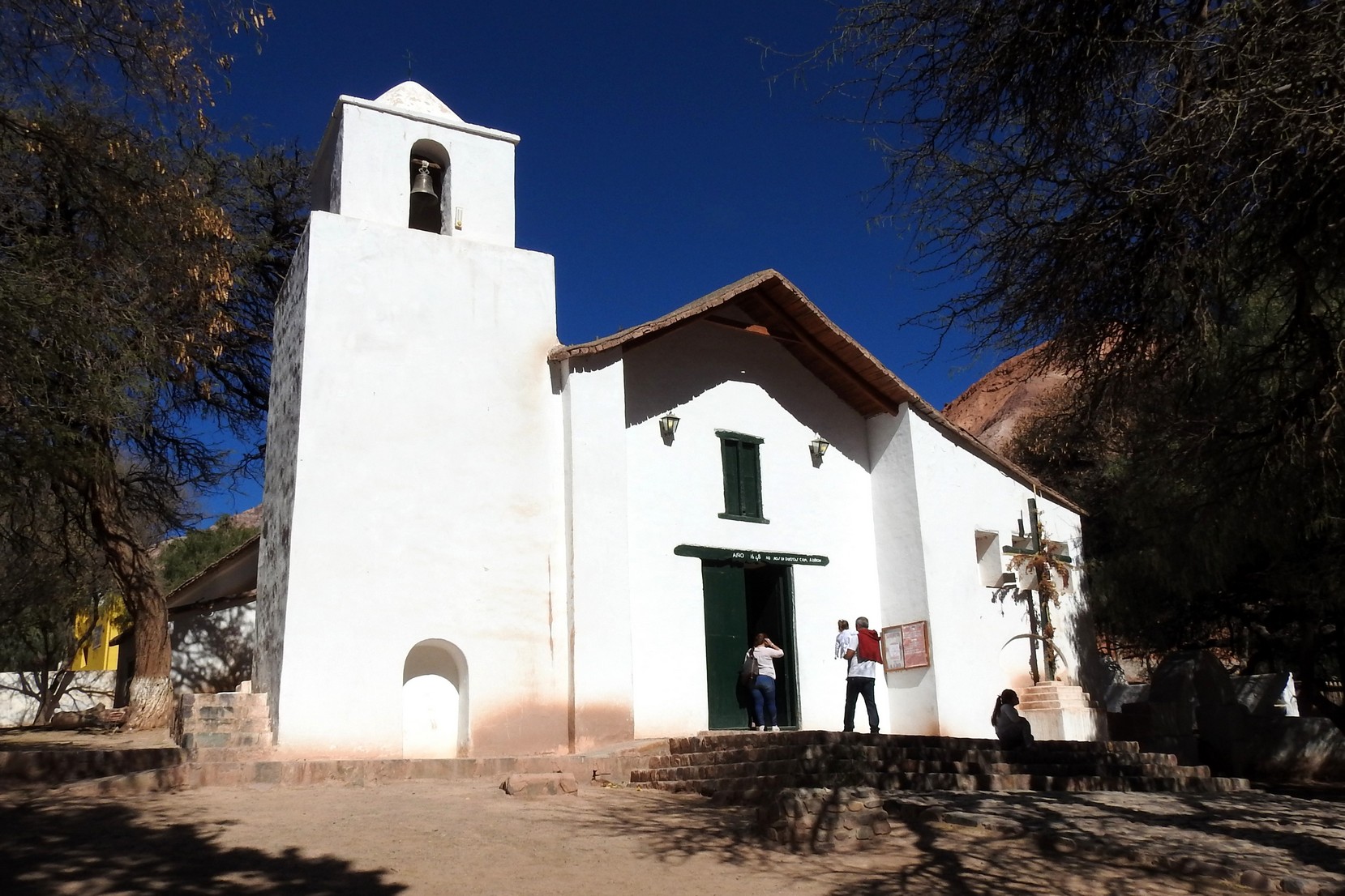
We had to drive back through Molinas so we stopped to see its church from the 18th century, built in the Cuzco style with two bell towers.

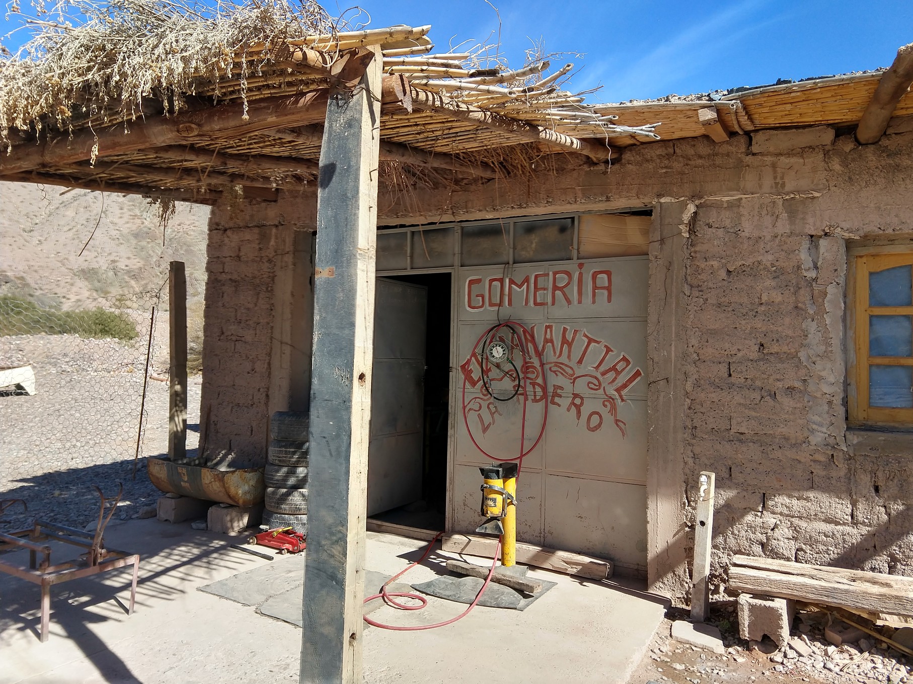
Shortly after we drove away from here we passed a small village called Seclantás

and we stopped for a bathroom break along the road; uh oh we heard hissing! We had a tire leaking but luckily it was not too far gone. Doug was ready to drive us to find some shade when Fran suggested we drive back the 2 km to the town see if we could find a gomeria (tire repair) and lo and behold as we approached the town, Doug saw a woman and asked here where we might find one and it was right across the road!
The two young men there at first wanted to just change the tire for us, but Doug insisted and we had them remove it in the hopes of repairing it. There was an arrowhead sized rock stuck in the tire:
![]()

And they were able to remove it and repair the tire.
 Phew – worth the less than $5 to have them do it! Not much traffic travels this road but we did see a small black van with Brazilian plates go past as we were having the repair done and we waved at each other. We’ve not seen many overlanders at all since we left BA and are often alone in camp spots except for a few Argentinians – this time of year is their school winter break.
We carried on to Cachi, found a spot on the street to park/camp and went for a short walk.
Cachi is a cute town to wander in but very, very small and really just a layover for us and also popular for bus tours from Salta as an overnight stop as we saw a good number of foreigners.


We stopped to have a beer and snacks at a bar on the square


While sitting there a man approached us and asked if we were from Canada. He was the man in the Brazilian vehicle we’d seen pass us while getting the tire repaired! Marcos lives in Sao Paolo and he and his wife are on a 60 day journey around southern South America. We hope to meet up with him in his home town to which he has invited us. He spoke perfect English as he’d lived in the US for a while – goo thing: we do not speak Portuguese!
Cachi has a three-bell towered church:

As we had approached Cachi, we’d hit paved roads and were hopeful going north was paved but before airing back up, we asked someone while still on pavement and were told “no such luck”; pavement ended shortly after the next town and turned back to dirt but not as full of washboard sections or curves as the road from Cafayate to Cachi. The scenery was more interesting too.
Today we had a longish drive planned as one of spots we wanted to see was at higher altitude than we’d like to sleep at these days with the cooler night time temps. The town of Cachi was at 2337 m / 7667’ and quite comfortable at night. We want to get up high and still have time to descend before dark to a more reasonable altitude.
Our first point of interest stop today was the Puente de Diablo (the Devil’s bridge). It was a short hike to a view point of a bridge that covers the river for 111 m / 364 ft.

In the photo above, you can see the river, then it’s covered in the bottom half of the picture – that is the 111 m long bridge

and then you continued on a view point then further on to where you could see inside a cave full of stalactites.


It was a fairly easy walk down but going up at this altitude (2880 m / 9400 ft) was not so easy; we both felt the thinner air.
We continued the drive northward and here are a few videos of our drive through the Monument Angastaco – an area we’d heard and read about as being spectacular.
Enroute we had 16 shallow creek crossings including three frozen ones. Brrrrr!
We continued going upward until we reached the Abra del Acay – the highest point on the Ruta 40 at 4972 m / 16,312 ft! Boy was the air thin and the wind COLD up here! We’d read about a “resident” fox that wanders up here hoping to be fed and lo and behold, there he was:


On our descent we encountered llama herds on the road at around 4000 m / 13, 100’ and and later guancos, vicunas and donkeys .


We arrived in the town of San Antonio de los Cobres shortly after lunch and passed through on our way to Viaducto la Polvorilla – this is very high rail viaduct that was built to be a tourist train. The Tren a las Nubes (train to the clouds) runs from Salta here through many scenic vistas but at this time of year we were told only from San Antonio and only on Saturdays.
Fun facts about the Train to the Clouds:
- The full train ride is 264 km / 164 m one way
- It passes through 21 tunnels for a total length of more than 3000 m / 9842 ft
- It crosses 31 iron bridges and 13 viaducts
- This viaduct is 64 m / 209 ft tall; 224 m / 734 ft long; weighs 1600 tons
- Magnificent engineering achievement that is considered “unjustified on any reasonable economic grounds”.
As luck would have it, today was Saturday. As we approached the viaduct, the train was crossing! After it crosses westward, it turns around and goes back to San Antonio.


We watched it and then drove to the parking underneath it.
Now, as mentioned about, our plan was to head down from 4200 m / 13,780 ft to a more sensible altitude for sleeping – down under 2000 if we could make it. We stopped in San Antonio de los Cobres for gas and to air up the tires as the highway 51 we were going to take towards Salta was 95% paved.
We made it about 140 km / 86 m to a wild camp 35 km / 21 m before Salta and parked in the tiniest village beside their chapel where others had stayed before us; our only company was some sheep and a few homes 100 m away. It was a dark and quiet night.

Sunday morning was a good day to drive into the large city of Salta (we hate driving into big cities on weekdays) and made our way to a large grocery store for shopping and then parked near downtown to do some walking and check out the architecture of the city.


We got out of Salta in the early afternoon (no decent places to spend the night) and made our way north into the most northerly province on the west side of the country: Jujuy. We drove through it’s capital of the same name to a small suburb called Yala where we camped in a campground for two nights. It offered full services and was off the highway so very quiet.
Next morning we saw a camper van with Washington state plates and met Michel and Anna from Switzerland who had bought their van from an Austrian overlander who’d purchased it from an American overlander. We invited them for happy hour later that day. Here we had no power issues like the last campground, which confirmed that the problem was not Tigger, but the power in the Cafayate campground. We spent the day catching up on things including cleaning etc.
At six o’clock we enjoyed happy hour with Michel and Anna before dinner and a quiet night.
Tuesday we decided to continue on through the Quebrada de Humahuaca (which started just south of where we are camped and stretches 130 km / 80 mi to beyond the town of Humahuaca) but before leaving we had to air up the tires – one was extremely low – that darn back one (this was one of the two crappy Dunlop tires we’d purchased back in Santiago – the other died a while back) and this one continues to get flats. When we were done we went to leave and the battery wouldn’t let us start so we had to jump it from our auxiliary and finally went on our way.
During this time, Fran noticed how loose the passenger side headlamp was; there was a piece missing to hold it in place. So Doug jerry rigged a tent peg and we locked it with a tire cap and voila:

We stopped in the town of Volcán about 26 km / 16 m away at a Visitor’s Centre to get route info and highlights of the area. Doug checked the tire again and it was losing air again so we needed to find another gomeria to help us out.
We found one at the turn off to Purmamara and the fellow found two leaks both in old patches. He really just wanted us to swap out our spare (like the other repair place) but he did repair the two holes but afterwards when he aired it up, he told us that it wouldn’t hold long and it needed a much larger patch than he could supply and recommended we drive 60 km / 40 m south to the city of Jujuy and find a better equipped tire repair place or buy a new tire.


So….he aired us up and southward we drove. On maps.me we saw that there were two Bridgestone shops in town so we made our way to the one closest to the highway and parked. It was siesta time and we had to wait until 4:30 for them to reopen. When Bridgestone opened, Doug spoke to the sales desk and they couldn’t help us with a repair or a new tire but recommended a Michelin place in the city that should have it.
We drove there and as we pulled into the garage and waited for someone to help us, Doug noticed the other back tire had a screw in it!

We were then told “no we don’t have either of your sized tires and it will take up to 15 days to get them from Buenos Aires”! Also, the tire would cost us $400 for one! (Just like we paid back in March in Trelew for the 265 spare we bought.) He did call around for us to some used tire places and finally came up with one at the place we’d read about on iOverlander as a good place for tire repairs.
We made it there after 5:30 and Manuel helped us right away parked right on the street across from the shop.

He first repaired the tire with the screw in it and then removed the one with all the patches. That one he determined was not safely repairable as it was wearing too thin. Doug asked him about a a new or replacement 265 tire and he had a slightly used one with what looked like good tread. So Doug arranged with him to put on that used tire and our new 265 from Trelew on the front and put the best of the 285’s on the back with the newly repaired one as the spare and we ditched the one they couldn’t repair.

By the time that was all done it was around 8:30 at night (yes he’d done all that work mostly after dark but there was a bright street lamp shining right over Tigger).
There was a partial blood lunar eclipse tonight but due to the overcast conditions, we were unable to view it.
Now it’s late, it’s dark and we’re hungry. There was a YPF station nearby that had a parking area so after filling the tank, we parked there, had a quick dinner. As the station was right by a main street neither of us slept well. We were up by 7:30, Doug aired up the back tires a bit more (they were not up as high as he wants them) and we left Jujuy.
We enjoyed our day today; we drove north to the turnoff to Purmamarca and headed along Hwy 52 out to the Salinas Grande (Argentina’s salt flats) for a short visit. In order to get there you have to climb the Cuesta de Lipan to a height of 4184 m / 13727 ft and then descend to 3457 m / 11,341 ft to the flats.


It’s quite touristy here with salt statues;

Salt buildings with vendors and small eateries with tables and benches made of salt:

And we wandered the stalls a bit. Fran saw nice etchings on pieces of rock that came with a hole in the top for hanging and wanted a small light one for our Christmas tree. We found a nice one but it was rather heavy (thick piece of rock) so after asking the vendor if he had a smaller/lighter one, he said he could make one in about five minutes for about $2! He first had us pick out the stone piece we wanted, then he etched the drawing of llamas, cactus and mountains with a sharp point; used a type of small spatula tool to scratch out a background; used a clear resin to colour in the pictures and voila:

What a nice souvenir – made just for us!

We turned around and headed back towards Purmamarca. Enroute we saw vicunas:


and lots of striped/coloured mountains:


We parked outside the village and then wandered the small tourist town. It was full of gifts shops and vendors and of course, tourists. The main reason we came into the town was to see the church with the same name as the one we were married in back in Sooke, BC in 1981: Saint Rose of Lima. This one dates back to 1648.
It was about the same size as that church in Sooke but whitewashed, a bit narrower and though slightly longer. That was neat. They would not let us take photos inside (so we got this one online):

The church we were married in:

We walked up to the Mirador to better see the Mountain of Seven Colours:
(this video done on a phone camera does not do justice to the colours so there’s photos below)


By 1:30 we were at a wild camp in a nearby dry riverbed and relaxed for the afternoon.
Next day we went to the “piece de resistance” of this area: El Hornocal – the mountain of 14 colours.
First we had to drive north to the small cute town of Humahuaca passing the Tropic of Capricorn

in which we stopped for a walk.


And then 24 km of dirt road to the lookout over the mountains that was amazing.


Here we were up are 4350 m and again, the air was thin but not too cold. We enjoyed the view, made brekkie, enjoyed the view some more and went back down.

Today should be our last day at significant altitude in the long foreseeable future. We head “down” more tomorrow and then northeast which is only around 5-800 m above sea level (1640 – 2600 feet). The weather will get warmer, the nights not so cool and the days will begin to get longer. Yipiee!


We arrived in a town called Maimará where a small campsite with fast Wi-Fi we found on iOverlander was located. Well, it was small and it had hot water but the Wi-Fi was crappy. We decided to only stay one night.
[wpgmappity id=”193″]
We left Maimará around 8:30 and drove south back to the city of San Salvador de Jujuy for some errands and then northeast to San Pedro de Jujuy to spend what should be our second last night in Argentina for a long time.
We drove to a YPF station with Wi-Fi. Before using the internet for a while, we went for a walk to the town square across the highway:


That night, now that we are down around 400 m / 1312 ‘ only, it was warm and there was no chill in the air Saturday morning. After exercising etc. we made our way about 90 km / 55 m further northeast to the Termas to Caimancito – thermal hot spring pools. The weather is much warmer now and we are loving it; we’re sure in a couple of weeks, we may be too hot as we continue northward …..
There are three pools of different temperatures here:


And we enjoyed some time in each before enjoying a hot shower and moving on down the road. They used to allow camping here but someone must have spoiled it as you can only “day camp” now. There were a few families enjoying the day with bbq’s going. We believe it must have been quite nice in its prime but now, like so many places in Argentina, it needs some TLC. The water was enjoyable and clean but the pools could use some paint and other amenities need sprucing up.
We left and continued on to Embarcación to yet another YPF station, one of the last cities before the border with Bolivia, which we intend to get to tomorrow.
For this part of Argentina we are back in Salta province but the landscape is flat and green with many sugar cane fields:
After a noisy, very warm night at the truck stop, we figured it was time to head to the border and beyond to a campsite with facilities. We drove the 145 km / 90 m to Salvador Massa, ARG which borders Yacuiba, Bolivia filling up with gas before hitting the actual border.
The whole process (checking out of Argentina, into Bolivia, cancelling one TIP and getting the new one) took just under an hour.
Argentina, you have impressed us; we’ve enjoyed many deserted and paved highways, mountains, abundance of campsites (including gas stations with showers & internet), pampas, penguins, guanacos, beaches, wine, deserts, beautiful cities, and warm people and especially your alfajores! Hasta luego for a few months.
NOTE: We will be back in Argentina once again sometime around October/November to check out the “arm” of the country that sits between Paraguay and Uruguay, in particular the Iguazu Falls region. Logistically, it made more sense to leave this part of the country until that time.
Sidebar: Since we entered Chile ten months ago (back on September 20, 2018), we have crossed the border several times between these two countries so we have combined the mileage for a total of 23,646 km / 14,639 miles: this was more than we did crossing Canada and almost as much as we did in our year traveling the USA; just from Ushuaia we’ve done 10,533 km / 6,545 mi since March 11th!
PS – We are off to Bolivia and western Brazil next; we anticipate cell signals and WiFi to be infrequent in this region so it could be a while before the next post but we’ll do the best we can. We appreciate your following along with us and remember, there are lots more photos in the galleries! Salud!