May 27th
Today we began our drive to the less visited Western Fjords – well away from the ring road. But first we had the “troll peninsula” to drive around for a 186 km / 115 mi scenic drive in the sunshine (also not part of the ring road). This apparently resembles the western fjords due to its craggy mountains, deep valleys and gushing rivers. Used to be that you could not drive around the entire peninsula although there are a few of roads across which of course are F roads so not passable this time of year. They put in a tunnel now that makes the drive possible.
Heading north we passed through the small town of Dalvik where you can catch a 3 hour ferry to an island on the Arctic Circle called Grimsey. We did consider doing this but it meant devoting an entire day to this pursuit so we chose not to as the island holds little else of note that we hadn’t already seen.

Sidebar: we understand Dalvik is where the Icelandic television show “Trapped” was filmed. We have now begun watching it and highly recommend it – it comes with English subtitles.
After we reached the town of Olafsfjordur, we drove through the new one way tunnel to Siglufjordur. This was weird! It’s about 7 km / 4 m long and there are pullouts so you can pull over if a vehicle is coming; we’re still sure which direction had the right of way so we pulled over the one and only time we saw a car coming at us.
There was another short tunnel later on with a “rest area” next to it. We’d been meaning to mention this. All this rest area signs show a tree and a table like in many countries BUT here in Iceland, we NEVER saw a tree at any of them; once a small bush beside the table only, but never a tree. 

On the west side of the peninsula, we drove past the town of Hofsos where we saw a large chunk of rock out in the ocean, that reminded us a bit of Perce Rock in Quebec.

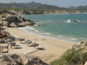
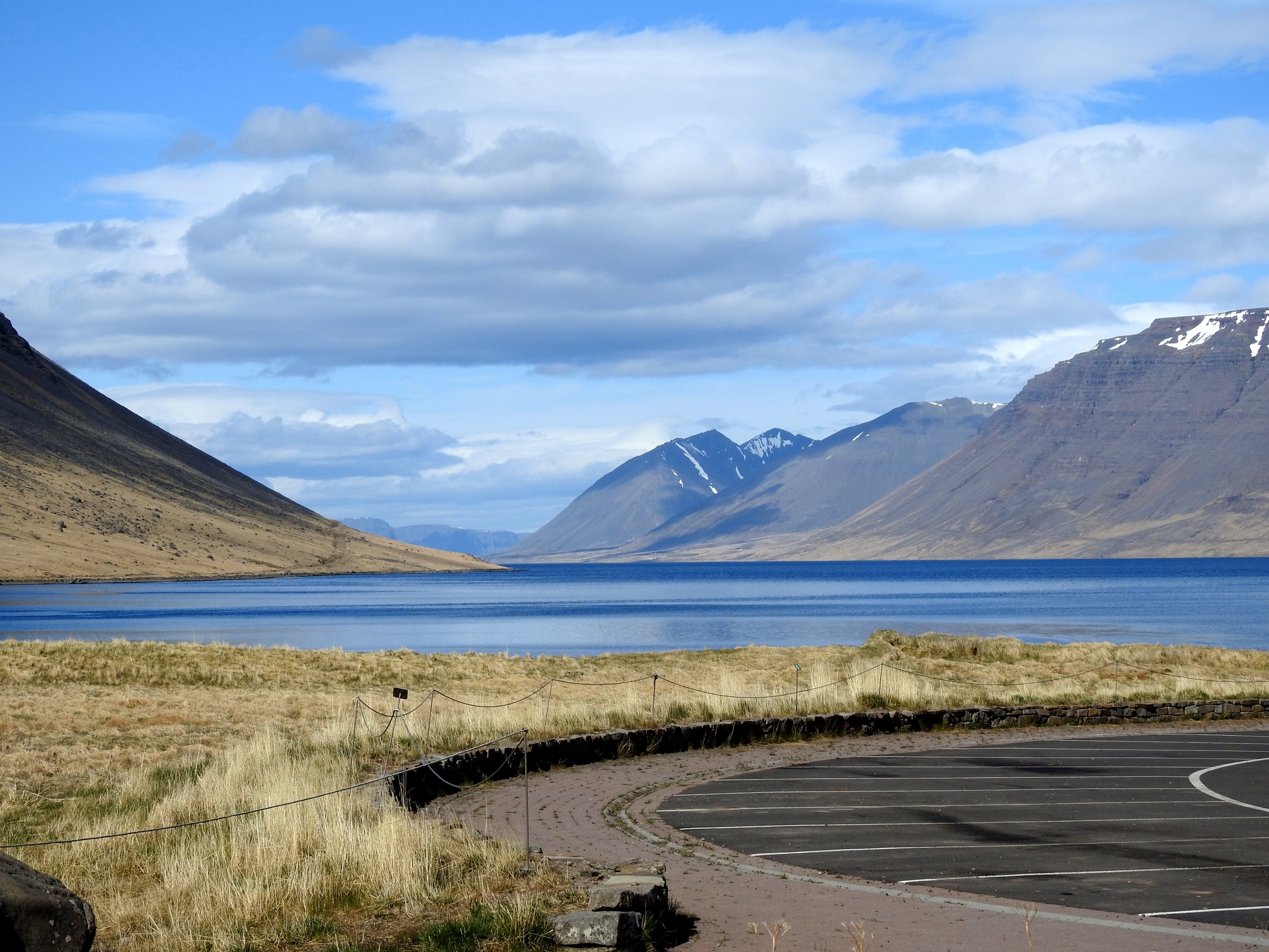
Views as we drove around the top of the peninsula:


 We drove inland a little further south, about 12 km / 7 mi to the small town of Hólar to see a church in this beautiful valley.
The bishopric of Hólar was the ecumenical and educational capital of northern Iceland between the 12th and 16th centuries and it continued as a religious centre until the end of the 18th century. It then became a vicarage until 1861. The present agricultural college was established in 1862 and is now known as Hólar University College. This school specializes in equine science, aquaculture and rural tourism.


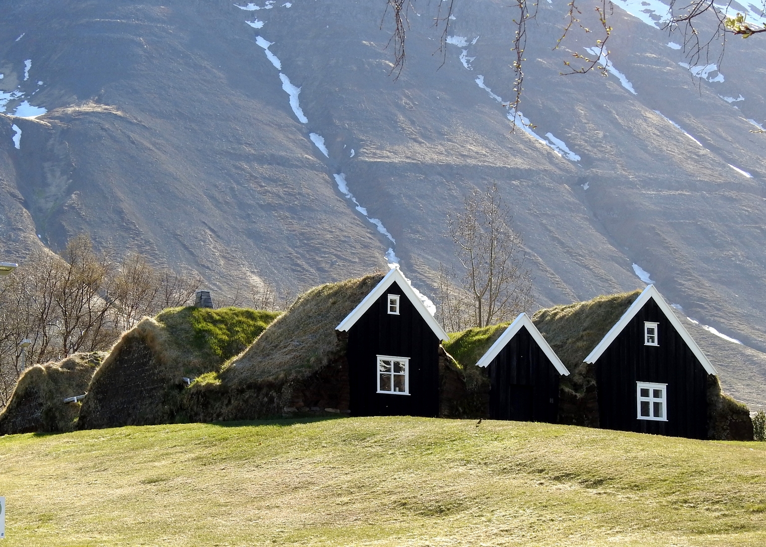
The National museum has preserved and renovated a turf house here.
The photo below is of Nyibaer which is an example of a medium size turf house of the north Icelandic style. This type of turf house emerged in the 19th century and is distinguished by the forward-facing gables on all the front buildings, and having the rear facing buildings arranged at right angles. Nyibaer is a national historic site and has been extensively renovated with the most recent renovations being done between 1997 and 2000.

After leaving that peninsula we made a detour off the ring road once again to visit Glaumbaer which is a museum site of a traditional turf house built in the mid-18th century and you can wander through it.
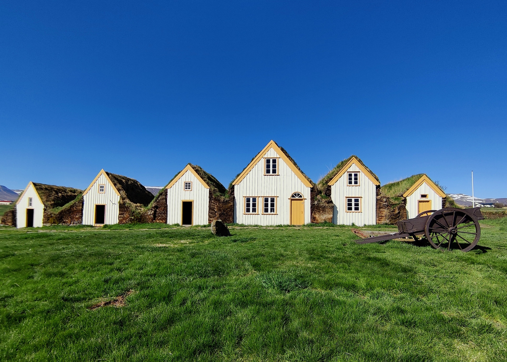

Here we had to pay for the entry and managed to get the senior rate without ID even though age 67 is a senior in Iceland. The site is well maintained and there are young people dressed in period costume to answer your questions.


Driving to the next peninsula, Vatnsens, once again off the ring road, along its eastern edge, we came across Hvitserkur – a 15m / 50’ high sea stack of said to be a troll.
Legend tells us of a troll caught by the sunrise while attempting to destroy the monastery at nearby Thingeyrar. Using a little bit of imagination, it looks like a troll (or stone beast) bent over drinking from the sea.

We returned once again to the ring road southwesterly to Route 68 where we left the ring road once for a few days and headed north towards Holmavik in the Western Fjords where we had booked a room; once again at a guest house.
Our plan was to head out for a soak in the hot pool at nearby Drangsnes before dinner, and then tomorrow go north along the most easterly western fjord to an infinity pool/hot pot at Krossneslaug – it sounded beautiful as it was right by the sea. Enroute to Holmavik Fran found a telephone number for the latter pool and after advising a few times that she did not speak Icelandic, was told in English, “Pool is closed”. That saved us a huge chunk of driving but we were awfully disappointed as this sounded like a wonderful spot. Oh well, another reason to return one day….
The guest house we booked was an old house that was turned into a guesthouse with narrow staircases and old windows. It had character but it was the most expensive place we stayed at €103. One other couple from the States joined us but we all kept to ourselves.

We grabbed some towels and our swim suits and made our way to Drangsnes. We found the hot pots – again just hot tubs right beside the side.

As you can see there are three of them. Two couples from the Czech Republic had also just arrived in two motorhomes and had taken up residence in the middle one by the time we’d showered and changed . The first pool looked quite gross so we tried to get into the 3rd pool. It was WAY too hot! After a few minutes, Fran went over to check out the temperature in their tub, it was perfect and asked if we could join them. (We’re pretty sure they knew how hot it was and as they kept goading us to get in already and were having a good chuckle at our expense :).) The setting was quite lovely and we had a beer while chatting to them and then after about a half hour, changed to return to our accommodation for the night.


Weather today – Sunny ALL day
May 28th
The western fjords are comprised of “three fingers”.

Holmavik and Drangsens are at the head of the inlet near the base of the most northerly finger and today we were headed inland near the point near where the middle and southerly fingers meet to see another waterfall. In order to get there from Holmavik we first have to reach the southern shore of the southern finger.
You might say, “ANOTHER waterfall? Really?” Well besides really enjoying waterfalls, this one definitely ranked up there and it’s not often visited being in the western fjords. The route there was paved at first then on and off pavement as we wound our way once again up and down fjords.


Upon reaching the southerly side of the southerly finger, we stopped to wash the car to take advantage of a chance to get all the mud off the car.

There was a nearby hot pot we wanted to check out that we might stop when we return to this point later. However when we tested the water temperature, we changed our minds; it was barely bathtub temperature although you have to agree the surrounding scenery was lovely in the sunlight.

We drove to the nearby turn off where you go inland to Dynjandi. The road here was under construction for the first few kilometres but after that was a good gravel road climbing and meandering around the hills with views of the fjords below.


We arrived at Dynjandi, which was a truly an amazing sight. There are so many waterfalls and viewpoints, the site just kept giving us more and more eye candy.
Its name means “thundering noise” and it’s the largest waterfall in the western fjords. It is 100 m / 330’ tall and 30 m / 10’ wide and below it are seven more waterfalls. The western fjords are the oldest part of Iceland. They originated during a series of volcanic eruptions that took place around 15 million years ago. After an ice age that took palace 10,000years ago, the progression of the glaciers had carved deep valleys and fjords in the landscape leaving behind layers of rock of different degrees of hardness. Their layers form the terraced waterfalls of Dynjandi.


We were able to climb up to the base of the main falls of Dynjandi stopping many times enroute for amazing views not only of the many waterfalls but of the scenery around us.


This was pretty much it for the day – our shortest driving day because if we moved on to the next attraction, there was no place to stay for a long way.

We did have a hot pot in mind enroute to our booked accommodation, but upon arriving at it quickly said “uh, no thank you”.


So we made our way back to the coast road where we came across this unnamed waterfall:
 and then on to what was probably the nicest guest house we stayed at in the coastal town of Patreksfjordur. We did stop at the village of Bildudalur for what was supposed to be wonderful views but by this it had clouded over once again and the mountain tops across the fjord were not visible but the bottom halves of waterfalls were endless. We bought a snack and moved on.
Stekkabol Guest House was comprised of two buildings and we were taken to a lovely corner room on the second floor with a view of the water. The kitchen was very well stocked and the Wi-Fi was super fast. The bathroom had a heated floor and the shower had a rainwater shower head. We cooked a simple pasta dinner that night and enjoyed a restful sleep. This was one of the few days we quit driving early – around three and had a more relaxing down time.


This was also the only guest house we stayed at that was offering breakfast and it was a wonderful buffet style. We think there was at least one other room occupied during out stay, but we never saw another guest. We had the lovely breakfast room to ourselves and were treated to hot waffles with fruit, cheeses, meats, smoked salmon, cereals, yoghurt (very popular here) and lots of juices and hot drink choices. We ate way more than normal and didn’t need lunch that day!
Weather today – started out mostly sunny then turned wet in the early afternoon
May 29th
Overnight it continued to be cloudy, rainy and foggy and we awoke to the same with some strong winds thrown in for good measure. It was too bad as we were headed to check out some beaches; yes, beaches – not that we’d get in the frigid water, but the sands were supposed to be different colours other than the standard black most beaches have here.
To get there the road went across the peninsula in some barren highlands.

Along the way we saw a small waterfall but due to high winds, the water was “falling” up not down!
When we reached the coast, Breidavik beach was first – it was golden sand – however, it seemed impossible to access. There is a tiny sort of town here and you can see the beach from the road that goes along above the town parallel to the beach but the one road down was blocked to vehicle access and it was still raining.
Just past the beach we came upon a double rainbow!


The next small beach town was Hvallatur, which had a white sand beach. It was white and we were able to access it much easier that the previous one but it was so, so windy.

As we headed uphill some we caught this shot looking back:

The next beach was along a sort of inlet that we could see from the cliff road we were on and it was still raining. It looked kinda pink as “advertised” but access seemed impossible and we didn’t want to get stuck in wet sand.
It was on this road we saw a second waterfall in reverse. This one had more flow and the effect was even funnier.
We drove now to the tip of the peninsula to Latrabjarg where the Bjargtangar lighthouse and bird cliffs are located. We took a difficult stroll struggling in the wind. One time, as Doug was leaning forward into the wind, it stopped and he almost fell on his face!
Latrabjarg is the site where a dramatic sea rescue took place in 1947. A local farmer received the distress signal from a British trawler that was stranded off the rock. He gathered other locals from nearby and they made the extremely dangerous decision that four of the twelve farmers would rappel down the cliff face to the shore and walk half a kilometre carrying rescue equipment across icy rocks to reach the twelve survivors of the wreck (three men had already drowned). A line was shot out to the ship, and each crew member was drawn on a rescue chair one at a time to shore. It took about an hour to get them all to shore and after that they were lead to the rocks under the cliff. Before dark and with the tide coming in, seven of the men had made it to the cliff face. The remaining men had to shelter for the night in the rocks and wait for dawn before reaching the cliffs. The entire next day was spent pulling the men up the cliff face in the wind and rain. They all camped overnight at the top and the next day made it to the farm. Almost all of the residents of nearby Hvallatrar participated in this heroic event as well as people from the farms of nearby Utvikur. While the men rappelled down the cliffs, the women and children took care of getting supplies to the point including tents, dry clothing, food and water. The photo below is from the movie made about this rescue.


We saw a few puffins here and several razor-billed auks as well as the common fulmars and kittiwakes and guillemots. Ten different birds nest here and it is estimated that by summer there are over one million birds here. This is the largest nesting ground for razor billed auks.


The razor-billed auk is jet black and white similar to a guillemot but is defined by the knob like nose and longer tail. They are deep divers, feeding on fish (including shellfish) and breed along North Atlantic coasts; some migrate as far south as the Mediterranean Sea.

After getting cold enough, we returned to the car and made our way north back along the same route to reach the main road and began the journey out of the western fjords.
This was going to be a long driving afternoon as there it was a long way to the next stop on our planned route. We had to go back up and down all the fjords we’d travelled two days ago, then inland a ways into Western Iceland and the Snaefellsnes Peninsula. Our maps.me wanted us to take a long way around but we sorted out a much shorter route on gravel roads. We made one stop here along the north coast of Snaefellsnes to check out an old church and graveyard while making our way to the small city of Stykkisholmur.

In the town, we visited a set of rock cliffs jutting out into the ocean that was supposed to have had more bird cliffs, but we saw none. The ferry to the western fjords docks here and perhaps the harbour/marina has sent them to other nesting grounds.


We made one other stop in town to see their futuristic looking church.

Fran found us a guesthouse near Grundafjordur and we called it a day by late afternoon. Here we had a lovely room with patio doors that looked out with a view to the famous Kirkufell. Unfortunately, due to the heavy fog we could barely see it. There are many waterfalls in the surrounding cliffs, also hidden from view due to the weather.


GOT Fans: this is the mountain shaped like an arrow
Our room also had a lovely sitting area facing the view and we had a comfy place to sit, eat and watch our shows. The kitchen area had two cooking/cleaning areas and the internet was very good. There were just two other rooms occupied during our stay.
Weather today – cloudy, rainy, super windy and foggy
May 30th
We had a good night’s sleep and sadly it was still foggy the next morning and the “arrow mountain” was still rather socked in but as we drove closer, we took a few shots from different angles – this was the best:

We couldn’t take the classic famous picture due to the fog but we were okay with that.
We carried on through a few little towns including Olafsvik where we saw a modern church made entirely of triangular pieces.

Then we drove into the National Park. The main road goes inland and the park road becomes black lava gravel. Our first point of interest was a Viking Grave at a little pretty beach called Skardsvik.
The signage tells of a “pagan” grave that was found here in 1962. It consisted of a burial mound raised over the skeleton of a young man. The skeleton was found relatively intact and there were a few complete items of value: a sword, a spearhead and a pin made of bone found with it. There were also pieces of a knife, an elaborate shield and bits of iron. The skeleton and the items are houses in the National Museum.

The drive towards the point of the peninsula was pretty barren. We made a stop at a small parking area for a break and there was a walk to a volcano that started there. As it was raining and there didn’t seem to be much of interest on the walk that we couldn’t already see, we passed.

We arrived at the point and took a walk around the area and came across the entrance to an ancient well:


Doug began walking down; it was dark and not very far in he stepped in water! Fran then went in with her camera and captured this using the flash:

The “falki” (well) is protected but no one knows when it was dug or who set the stones. This is the only water reservoir in this area and has been used by locals and visitors for a very long time.
Legend says it has three sources: one is fresh water, one is holy water (supposed to be very healthy) and the third source is ale. It is also said it is bad luck to draw water from this well after sundown.
The beach area was a place where many fishermen docked and made their way up through the rocky shore to the grass to moor their boats. We searched amoung the rocks for the groove marks that were supposed to be there but found none that we were sure about.

We found a boardwalk out past the lighthouse and spent a little bit of time trying to spot whales with no success. This is considered the most western point of Europe.


We drove a little further down the gravel road to the next lighthouse where we were able to see a large arch and many birds.


Here we came across a new bird we’d not seen: a Brunnich’s Guillemot:

Brunnich’s Guillemot is also known as Thick-billed Murre is a northern bird that nests in Iceland – the most southerly point that it flies. It is becoming more rare as time passes. It is larger than other auks and looks very similar to common guillemots but it has a white line on its upper mandible. It does not make an actual nest but lays its eggs on bare rock ledges.
We also so razor-billed auks and common guillemots:


We made the decision to take the gravel inland route to the south side of the peninsula rather than return to the paved road. Here we came across a couple of small summer towns, Hellnar and Arnarstapi. Neither town was very busy this time of year except for fishermen.
The saga of Bardur, who was part giant, part troll and part human, takes place in and around this peninsula, especially in Hellnar. He chose this area to live and nearby is a pond called Bardarlaug, which was said to be his bathing pool. Near the end of the saga he becomes the spirit of Snaefell.
This small lake is considered to be the “pool” he bathed in:

In Arnarstapi, there is a weird “monument” that supposedly pays tribute to Jules Verne with a signpost measuring the distances to various major cities via the earth’s core – very questionable!

This town has a monument to Bardur as well:

We made one stop off the road at a beach where seals apparently like to sun bathe but we guess that in this weather, they decided to stay out at sea as we saw not a one! Two types of seals are said to come to ashore here: the Grey Seal and the common harbour seal, the smaller of the two.
The highway moves away from the coast now and we made a small detour to the basalt cliffs of Gerduberg. This was pretty cool.


It was now early afternoon and the area we are in has few towns and even fewer places to stay. We decided to call it and push on to a guesthouse Fran found on Booking.com further south where this road joins back up with the ring road that was well priced and had a hot pot.
We had one more stop to make before checking in: the Settlement Museum in Borgarnes. This interactive museum displays exhibits on the settling of Iceland; you are given an audio headset and walk through the exhibits on your own; takes about a half hour.


Now we were back on Route 1 – the Ring Road. We had booked just a room at Hotel Laxarbakki and planned to use the shared kitchen. Enroute we tried to get a a view of a famous picturesque mountain called Hafnarfjall but the weather did not really cooperate here either:

Upon arrival at our accommodation, we were pleasantly surprised to be once again upgraded; this time to a suite complete with a kitchen! We asked about the hot tub and were told it would take about an hour to fill with fresh hot water straight from underground and we said we’d love a soak around 4:30. We got settled in, did a few things online for about an hour and then got changed to head over to the hot tub. It was still misty raining but nothing to deter us.

We walked down to the end of the hall and opened the door to outside. We saw this really was a regular large hot tub and the cover was off as there were two younger men already soaking. They were from the east coast of the US and we joined them in the nice hot water and enjoyed a beer before going in to make dinner and crashing after a longa$$ driving day.
Weather today – cloudy, rainy, super windy and foggy
Please remember to check out our galleries for more photos!