February 15th, 2022
We were up at 4:30 to catch our early flight to Aswan – took an Uber to the airport and the flight was on time – we’d booked Business Class as economy was full so we got breakfast on the plane.. We took a taxi from the airport in Aswan to the ferry to get to our guest house on Elephantine Island recommended by Josée. We had arranged with our taxi driver, Saffy to meet us back at the ferry a bit later and take us to a few sights in the city.
Elephantine Island is so called as back in ancient times this is where the ivory trade took place after hunting. The Island separates the Nile into two channels opposite the city of Aswan.
To get to the island there is a small ferry that takes about 4 minutes to get across – you pay five Egyptian pounds (.32 USD) to go over and it’s free to come back. There are no vehicles on the island, only bicycles and wheelbarrows for transport.
So we dropped off our luggage as it was too early to check in and took a walk on the island for a bit before messaging Saffy and he met us the ferry at 10:30 and the first attraction on the agenda was the Unfinished Obelisk – we took a look through the fence and didn’t go in.
The unfinished obelisk is the largest known ancient obelisk. Its creation was ordered by Hatshepsut (1508–1458 BC), possibly to complement what would later be known as the Lateran Obelisk (which was originally at Karnak, and was later brought to the Lateran Palace in Rome). The unfinished obelisk is nearly one-third larger than any ancient Egyptian obelisk ever erected. If finished it would have measured around 41.75 metres (137.0 ft) tall and would have weighed nearly 1,090 tons (1,200 short tons), a weight equal to about 200 African elephants!
The obelisk’s creators began to carve it directly out of bedrock, but cracks appeared in the granite and the project was abandoned. The bottom side of the obelisk is still attached to the bedrock.
Doug then wanted to go see the newer dam on the Nile. There are two: the low dam (built in 1902) is close to the city and you cross it when going to and from the airport into Aswan. The British began construction of the first dam across the Nile in 1898. Construction lasted until 1902 and the dam was opened on 10 December 1902. The project was designed by Sir William Willcocks and involved several eminent engineers.
The newer , High Dam, is maybe fifteen minutes away and created the huge reservoir known as Lake Nasser. If you want to stop on the dam, you need to pay an “entrance fee” but we told Saffy we just wanted to drive across and then come back. A couple of security officers gave him a hard time on the way back but it was all good.
In 1952, a Greek-Egyptian engineer began to develop the plan of the new Aswan Dam. Although the Low Dam was almost overtopped in 1946, the government of King Farouk showed no interest in the plan. Instead the Nile Valley Plan by the British hydrologist Harold Edwin Hurst was favored, which proposed to store water in Sudan and Ethiopia, where evaporation is much lower. The Egyptian position changed completely after the overthrow of the monarchy in 1956 led by the Free Officers Movement including Gamal Abdel Nasser. The Free Officers were convinced that the Nile Waters had to be stored in Egypt for political reasons, and within two months, the aforementioned plan was accepted.
In the 1950s, archaeologists began raising concerns that several major historical sites, including the famous temple of Abu Simbel were about to be submerged by waters collected behind the dam. A rescue operation began in 1960 under UNESCO.
In 1955, America and the United Kingdom offered to help finance construction of the High Dam, with a loan of $270 million, in return for Nasser’s leadership in resolving the Arab-Israeli conflict. While opposed to communism, capitalism, and imperialism, Nasser identified as a tactical neutralist and sought to work with both the U.S. and the USSR for Egyptian and Arab benefit. For various reasons both the UK and the US backed out and in 1958, the USSR proceeded to provide support for the High Dam project. The Soviets provided technicians and heavy machinery. The enormous rock and clay dam was designed by the Soviet Hydroproject Institute along with some 25,000 Egyptian engineers and workers. Construction began in early 1960 and was completed in 1970; Lake Nasser reached capacity in 1976.
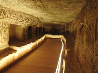
Saffy then drove us to the Philae Temple parking area and we were dropped off and bought our tickets. You have to take a boat out to the site and we negotiated a price for a private one to take us there for a max 90 minute visit.
Philae is an island in the reservoir of the Nile downstream of Lake Nasser. Philae was originally located near the expansive First Cataract of the Nile in Upper Egypt and was the site of a temple complex. These rapids and the surrounding area have been flooded at various times since the initial construction of the Aswan Low Dam in 1902. The temple complex was dismantled and moved to nearby Agilkia Island as part of the UNESCO Nubia Campaign project, protecting this and other complexes before the 1970 completion of the Aswan High Dam. \
Its ancient name was Pilak which means end or remote place. There have been as many as ten temples on this site.
Since Philae was said to be one of the burying-places of Osiris, it was held in high reverence both by the Egyptians to the north and the Nubians (often referred to as “Ethiopians” in Greek) to the south. It was deemed profane for any but priests to dwell there and was accordingly sequestered and denominated “the Unapproachable”. It was reported too, that neither birds flew over it nor fish approached its shores. These indeed were the traditions of a remote period; since in the time of the Ptolemaic Kingdom, Philae was so much resorted to, partly by pilgrims to the tomb of Osiris, partly by persons on secular errands, that the priests petitioned to prohibit public functionaries at least from coming there and living at their expense.
The temples had been practically intact since the ancient days, but with each inundation the situation worsened and in the 1960s the island was submerged up to a third of the buildings all year round.
In 1960 UNESCO started a project to try to save the buildings on the island from the destructive effect of the ever-increasing waters of the Nile. First, building three dams and creating a separate lake with lower water levels was considered.
First of all, a large coffer dam was built, constructed of two rows of steel plates between which a 1 million cubic metres (35 million cubic feet) of sand was tipped. Any water that seeped through was pumped away.
Next the monuments were cleaned and measured, by using photogrammetry, a method that enables the exact reconstruction of the original size of the building blocks that were used by the ancients. Then every building was dismantled into about 40,000 units from 2 to 25 tons, and then transported to the nearby Island of Agilkia, situated on higher ground some 500 metres (1,600 ft) away. The transfer itself took place between 1977 and 1980.
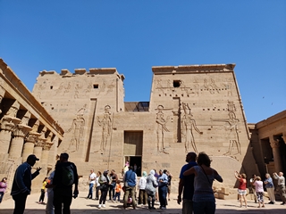
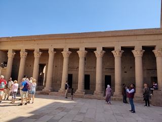
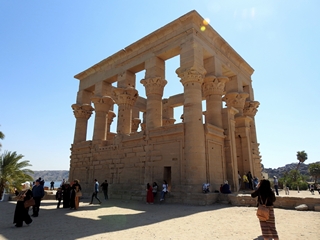
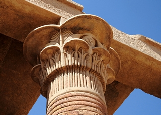
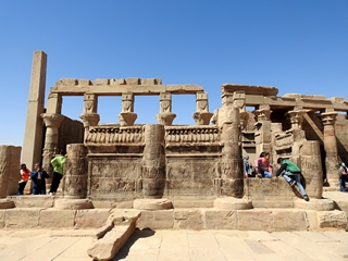
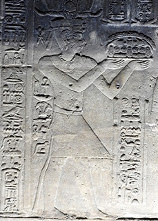
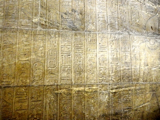
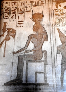
This visit was fantastic! We saw hieroglyphics and columns with both Greek and roman influences and the enormity of the place was spectacular. The fact that they moved this all piece by piece made it all that much more amazing.
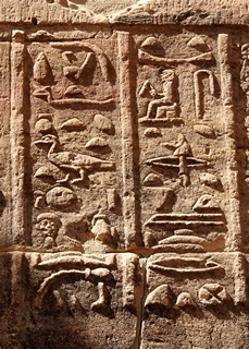
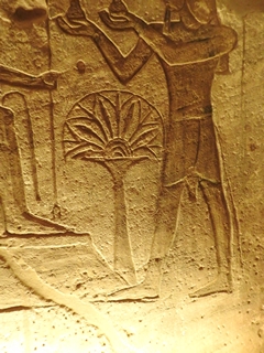
What is a cartouche?
In Egyptian hieroglyphs, a cartouche is an oval with a line at one end tangent to the oval, indicating that the text enclosed is a royal name.
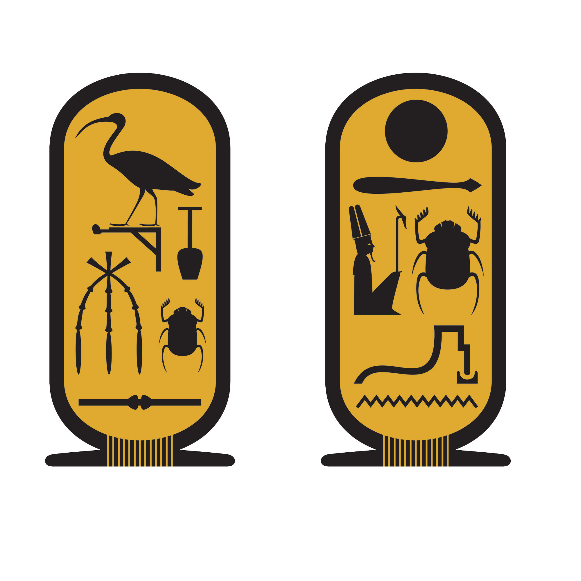
The first examples of the cartouche are associated with pharaohs at the end of the Third Dynasty, but the feature did not come into common use until the beginning of the Fourth Dynasty under Pharaoh Sneferu. While the cartouche is usually vertical with a horizontal line, if it makes the name fit better it can be horizontal, with a vertical line at the end.
At times amulets took the form of a cartouche displaying the name of a king and placed in tombs. Archaeologists often find such items important for dating a tomb and its contents. Cartouches were formerly only worn by pharaohs. The oval surrounding their name was meant to protect them from evil spirits in life and after death. The cartouche has become a symbol representing good luck and protection from evil.
The term ‘cartouche’ was first applied by French soldiers who fancied that the symbol they saw so frequently repeated on the pharaonic ruins they encountered resembled a muzzle-loading firearm’s paper powder catridge (cartouche in French).
As a hieroglyph, a cartouche can represent the Egyptian-language word for “name”.
We had Saffy drop us at the Aswan train station at the north end of the “souk” (bazaar) and we strolled our way down, had lunch and bought ourselves our traditional one souvenir – a Christmas ornament for the tree. We also bought Sayed a half kilo of hibiscus tea that he asked us to pick up as apparently the best hibiscus is here in Aswan.
We returned to the Mango Guest House in the afternoon; turns out when we chatted to book the place, he said they had room but it seems they were full so they put us in a small apartment across the road. It was disappointing as the ambience at the guest house was very nice and kinda defeated the purpose of spending time with other travelers but was comfortable enough. It had a full kitchen (which we didn’t need or use except for the fridge) and a bonus was a washing machine and there were clothes lines off the balcony (we were on the second floor).
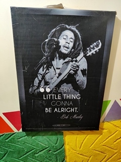
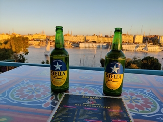
For dinner that night we went to a bar/restaurant that we’d seen a sign for at the ferry terminal. Bob Marley was a roof top restaurant with more than one level and we enjoyed some cold beer and tried Nubian tagine for dinner. It’s a dished cooked in a clay pot in the oven and serve with rice; you get a choice of chicken, beef, fish or vegetable. The music was good and the view across the Nile was perfect. We chatted with a young German couple during drinks and enjoyed the feluccas sailing by during sunset.
We had arranged through Saffy for a car and driver to take us to the Abu Simbel site on Wednesday. We had told the Mango Guest House that we’d want breakfast at 7 and they said it starts at 6:30 so no problem. Wel, no one was around and we had to message the owner to get him up! It was a lovely breakfast but we had to eat it fast.
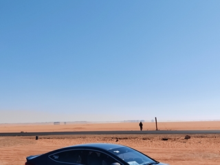
We met Saffy and his “brother” at the ferry terminal. Seems no taxis are allowed to go to Abu Simbel so that’s why we needed a private VIP car. The drive there is nearly three hours and it’s a pretty bare landscape enroute but the highway is a very good two lane road.
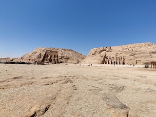
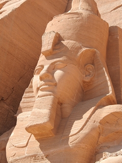
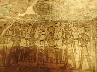
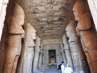
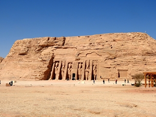
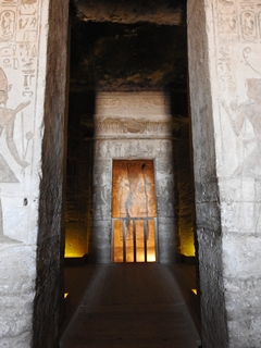
Abu Simbel is actually two massive rock-cut temples in the village of Abu Simbel near the border with Sudan. They are situated on the western bank of Lake Nasser about 300 km (190 mi) from Aswan by road. The complex is part of the UNESCO World Heritage Site known as the “Nubian Monuments”, which run from Abu Simbel downriver to Philae. The twin temples were originally carved out of the mountainside in the 13th century BC, during the 19th Dynasty reign of the Pharaoh Ramesses II. They serve as a lasting monument to the King Ramesses II. His wife Nefertari and children can be seen in smaller figures by his feet, considered to be of lesser importance and were not given the same position of scale. This commemorates his victory at the Battle of Kadesh. Their huge external rock relief figures have become iconic.
The complex was relocated in its entirety in 1968 on an artificial hill made from a domed structure, high above the Aswan High Dam reservoir. The relocation of the temples was necessary or they would have been submerged during the creation of Lake Nasser.
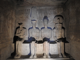
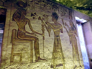
During his reign, Ramesses II embarked on an extensive building program throughout Egypt and Nubia, which Egypt controlled. Nubia was very important to the Egyptians because it was a source of gold and many other precious trade goods. He, therefore, built several grand temples there in order to impress upon the Nubians Egypt’s might and Egyptianize the people of Nubia. The most prominent temples are the rock-cut temples near the modern village of Abu Simbel, at the Second Nile Cataract, the border between Lower Nubia and Upper Nubia. There are two temples: the Great Temple, dedicated to Ramesses II himself, and the Small Temple, dedicated to his chief wife, Queen Nefertari.
Construction of the temple complex started in approximately 1264 BC and lasted for about 20 years. It was known as the “Temple of Ramesses, beloved by Amun”.
Carved into a cliff overhanging the Nile, the Temple of Ramses II is characterized by an astronomical phenomenon. Each morning the sun first illuminates a row of seated baboon monkeys that have their arms raised for sun worship. On two days of the year, the sun rays penetrate the temple and illuminate the faces of King Ramses II statues inside the sacrarium. It is thought that the carving out of the temple began fairly early in Ramses’ long reign; possibly commissioned during his fifth year but no completed until this 35th.
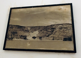
With the passage of time, the temples fell into disuse and eventually became covered by sand. By the 6th century BC, the sand already covered the statues of the main temple up to their knees. The temple was forgotten until 1813, when a Swiss researcher found the top frieze of the main temple. Burckhardt talked about his discovery with an Italian explorer who travelled to the site, but was unable to dig out an entry to the temple. The latter returned in 1817, this time succeeding in his attempt to enter the complex. In 1959, an international donations campaign to save the monuments of Nubia began: the southernmost relics of this ancient human civilization were under threat from the rising waters of the Nile that were about to result from the construction of the Aswan High Dam.
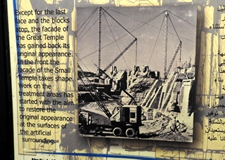
The salvage of the Abu Simbel temples began in 1964 by a multinational team of archeologists, engineers and skilled heavy equipment operators working together under the UNESCO banner; it cost some US$40 million at the time. Between 1964 and 1968, the entire site was carefully cut into large blocks (up to 30 tons, averaging 20 tons), dismantled, lifted and reassembled in a new location 65 metres higher and 200 metres back from the river, in one of the greatest challenges of archaeological engineering in history. Some structures were even saved from under the waters of Lake Nasser.
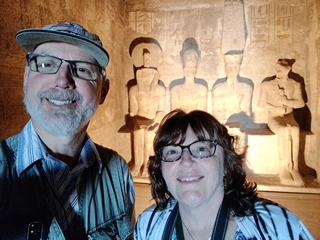
Upon arrival, we were dropped off and went to find the ticket office – which is sort of hidden for some reason. We had some information about the site in our guide book and used that to wander through both temples and were in awe at the size and immensity of the site and once again, at the amazing accomplishment of moving such structures.
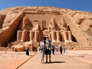
We also stopped by the Visitor’s Centre to learn more about the dismantling and rebuilding of this site.
In order to leave the place, like in many other sites, you have to walk the “gauntlet” of vendors selling their wares; here in Egypt it’s similar to in Mexico, constant hassle and pestering.
We arrived at the parking lot and could not find Achmed, our driver! He had told us no more than two hours as that was as long as he was allowed to park there and we were back well before that time. We had no way to contact him so Doug WhatsApp’d Saffy and we began to walk towards the town of Abu Simbel.
He found us and we expressed our disappointment – he had one job! The drive back to Aswan was a little tense and quiet. When he dropped us of he actually had the gall to be surprised he didn’t get much of a tip!
Fran returned to the hotel and Doug went to see if he could check out the Nilometre on the island but it had closed five minutes earlier. He went to pay our bill as we had to leave right after breakfast tomorrow to catch the ferry.
We couldn’t find a different place to eat dinner that night that had a view, nice music and cold beer so it was back to the Bob Marley bar that night where we had Nubian pizza – it’s quite doughy and has no cheese but the crust was delicious. Doug even managed to get them to give him a cold beer to take back to the room.
We had a more leisurely breakfast that morning after packing and made our way to the ferry and across the Nile to meet our pick up for the Nile Cruise.