March 26th, 2022
Upon leaving Ludlow, England, we then made our way across the “border” into Wales to spend the next week. There was no signage at the border but you know you’re no longer in England because the signs are bilingual: Welsh and English and for some reason not always in the same order; takes you twice as long to read them because for a while they are English then Welsh then they switch up and reverse!

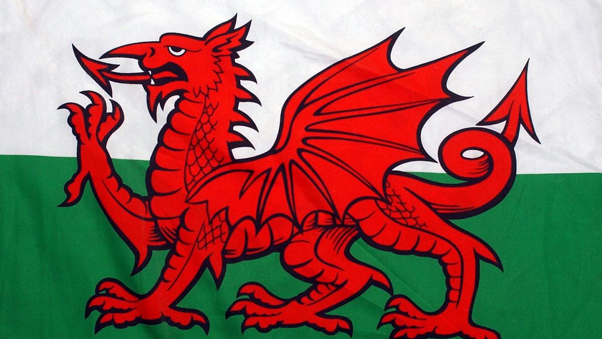
The Welsh flag has the red dragon of Cadwaladr, King of Gwynedd on a green and white background (Tudor colours).
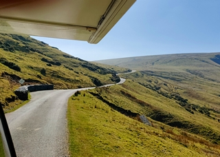
First stop was into a part of the Brecon Beacons National Park – we planned to do a hike in the hills but the drive was fantastic and we saw what we figured we see on the hike except for the first part at the trail head.
The scenery was beautiful on this another sunny warm day and we were captivated.


We made it to Llanthony Priory where the trail head was and checked out the Priory ruins.
Llanthony Priory is the ruined former Augustinian priory located within the Black Mountains area of the Brecon Beacons National Park in south east Wales.
The priory dates back to around the year 1100, when Norman nobleman Walter De Lacy reputedly came upon a ruined chapel of St. David in this location, and was inspired to devote himself to solitary prayer and study. He was joined by Ersinius, a Chaplain and then a band of followers. A church was built on the site, dedicated to St. John the Baptist, and consecrated in 1108. By 1118, a group of around 40 monks from England founded there a priory of Canons Regular, the first in Wales.
However, around 1186 another member of the de Lacy family, Hugh, the fifth baron, endowed the estate with funds from his Irish estates to rebuild the priory church, and this work was completed by 1217.
The Priory became one of the great medieval buildings in Wales, in a mixture of Norman and Gothic architectural styles. Renewed building took place around 1325, with a new gatehouse.


We took advantage of the washrooms at the parking lot and dumped our cassette too. They looked lovely in the sunlight.
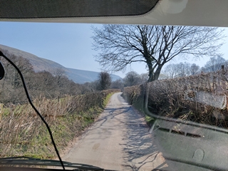
The road here was mostly a single track, sometimes bounded by hedges on both sides and at times we had to do some back and forthing when meeting other vehicles. Fun, fun, fun!

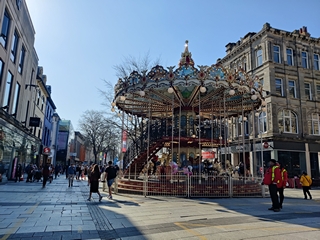
Since we decided not to hike we made our way to Cardiff to see the outside of its castle and to view the Antarctica 100 – Captain Scott memorial. Traffic got quite slow before we reached the capital city about 60 km / 40 mi south and it was at a crawl getting into the centre. We decided to go to the waterfront first – mistake – some of the access roads were closed (we think cause it was the weekend); Fran got out took a snap or two of the statue
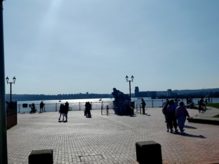

and Doug maneuvered us out of there. We found a place on the park4night app in an industrial part of the city to park for the night and went there. From there we walked the 2 km / 1.5 km into the city to see downtown and the castle. There are a huge number of pedestrian only streets (which probably explains all the traffic coming into the downtown and the full parking lots) and it was a pleasant walk in the sunshine.
Here in Cardiff the castle is free to enter and wander the grounds; you pay if you want to see inside the actual rooms.


We returned to after a nice walk downtown via a mostly different set of pedestrian streets getting some yummy ice cream enroute.
The Cardiff Half marathon is being un on Sunday (Doug is sorry he didn’t know but the registration is full) so we wanted to leave the city early to avoid any traffic issues; turned out we could get “under” the city via tunnel to head west so it may not have been an issue. Our first task was to gas up by the cheap gas station we found (Tesco stations) was out of gas so we mosied a little further on down the highway and found another at an even better price: £1.68 per litre! We went into the supermarket and asked at the pharmacy about a sling for Doug’s arm to help him not use it.
We made our way westward to the town of Pontneddfechan (say that 3 times fast after a beer or two!) to take a hike in Waterfall Country another piece of the Brecon Beacons NP. It was another gorgeous day and the hike was about an hour passing a few different ones.

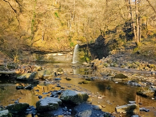

The path was pretty easy for the most part, some muddy spots, some stairs, a few foot bridges and some rocky sections but nothing really strenuous. It was Mother’s Day here in the UK and the mom’s got a beautiful day for it.
We then turned towards the coast to check out the Millennium Coastal Trail in Llanelli – which while well built and a great paved pathway of 13 miles, much of it is not right on the coast itself as there are train tracks in between but it was a nice for another walk.


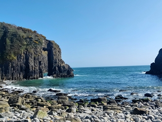
Then it was on to the a few cool sites right on the water. First was the Church Doors:
View from above:

View from the beach:

the small door:

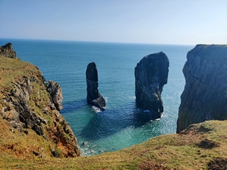
Next was the Elegug Stack Rocks:
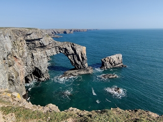
And finally, the Green Bridge of Wales: (it’s mossy on top, hence the “green”):
We found a nearby lay by to spend the night and the only neighbours we had were some cows kitty corner to us. It was super quiet all night and we both slept very well.

Now since we’d gone a day without a castle, we stopped in Pembroke to see theirs:
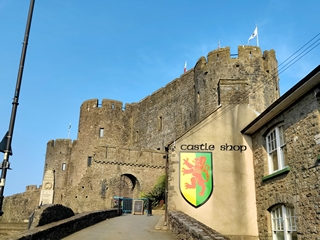

Pembroke Castle was the original family seat of the Earldom of Pembroke. It underwent major restoration during the early 20th century.
The castle was built in 1093, during the Norman Invasion of Wales. A century later, the castle was given by Richard I to William Marshal, who became one of the most powerful men in 12th-century Britain. He rebuilt Pembroke Castle in stone, creating most of the structure that remains today. The castle is open to the public and is the largest privately owned castle in Wales.
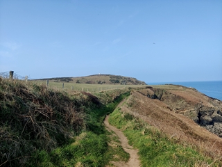
Then it was on to the Marloes Peninsula to do a hike on a piece of the 186 mile Pembrokeshire National Coastal Trail.
This was a pretty hike, mostly hugging the coast line around a peninsula with lovely views on yet another sunny day! It was about a 8 km / 5m circle route starting across fields and ending on a cliff above a sandy beach. There were cool rock formations, sadly no seals this time of year (or puffins!) and island views.


As we have finally (after tons of hassles online with our US credit card number) booked a ferry from Holyhead, Wales, to Dublin for Friday we want to make sure we do enough mileage everyday so as not to be rushed and Doug wanted to stop near there at the GasIt shop he’d ordered our new system from, in order to get some extra parts and ask for some advice. So we pushed on after our hike and breakfast as far as Cross Inn up the coast where we found a pub to park at in our new BritStops book. Kate and David had recommended this to us and we think the couple we met in Vega, Tom and Carol did too. This is a book you purchase (they are making an app) that gives you names of pubs in various towns that allow motorhomes to park out back, mostly in exchange for purchasing food and or drink. Sometimes there are amenities but mostly not.
This town had one of these pubs: the Penrhiwgaled Arms – yes another mangling word! As we were driving there, Fran checked online and it seemed they were not open Mondays and Tuesday – figures but we thought, it should not be an issue to park there unless the lot is closed
The lot was open and there was one vehicle there and another arrived right after us Doug asked if they were open and they said they’d open from 4 to 6 today and where we were parked was fine. We had hot showers (after switching out the gas bottles) and then went in for a couple of cold ones. We had another super quiet small town night.

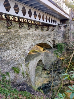
Tuesday morning we continued northeast and made our way to see the Devil’s Bridge Waterfalls and 3 bridges
Devil’s Bridge is unique in that three separate bridges are coexistent, each one built upon the previous bridge. The previous structures were not demolished.
The most recently built, in 1901, is an iron bridge which was erected above the older arches. The original bridge is medieval and the second one, a stone structure, built in 1753 and upgraded in 1777 and in 1814, was erected when the original bridge was thought to be unstable. The builders of the 1753 structure used the original bridge (c. 1075–1200) to support scaffolding during construction and added a second arch. The 1901 structure eliminated the slope in the roadway. In 1971, the steelwork and railings were repaired and the bridge was strengthened. The structure was deemed “as a remarkable succession of three superimposed bridges, one of the best known picturesque sites in Wales”.
The name in 1629 was Pont ar Vynach or Pontarfynach, meaning “Bridge over the Mynach”. The word mynach is Welsh for monk; one theory is that the river got its name from the fact that it was near land owned by a monastery. The first mention of the structure using the English name Devil’s Bridge, in historical records, is from 1734.
The bridge is at a point where the River Mynach drops 90 metres (300 ft) in five steps down a steep and narrow ravine before it meets the River Rheidol. The set of stone steps, known as Jacob’s Ladder, a circular walk for tourists, leads down to a modern metal bridge below the waterfalls.
According to legend, the original bridge was built after an old woman lost her cow and saw it grazing on the other side of the river. The Devil appeared and agreed to build a bridge in return for the soul of the first living thing to cross it. When the bridge was finished, the old woman threw a crust of bread over the river, which her dog crossed the bridge to retrieve, thus becoming the first living thing to cross it. The devil was left with only the soul of the dog.
Turns out if you get there before the “booth” is open, you pay £2 at the turnstile and can get it – down the first set of steps you can see the 3 bridges.
Then you walk the trail up and down the stairs called Jacob’s Ladder to see the falls that are in a several leaps. The first look out is the only one where you can see them all and you cannot turn around – this meant Fran had to suffer going down down down with sore knees and then up, up, up to get back to street level. Ouch! We’ve been doing hikes every day the past few days and it’s hard on her knees.


We pushed on northward through some mountainous country side.
We stopped at a Snowdonia National Park trail head and got our cassette emptied for free and then moved on to the town of Groeslan where GasIt is located. Doug asked a few question, got a few spare “olives” for free, and they let us fill our water tank.
A few miles further down the road is the city of Caernarfon (Carnarvon) where we walked around the castle and the walled city before finding a place to park for the night along the shoreline.
Caernarfon Castle often anglicized as Carnarvon Castle is a medieval fortress from the late 11th century until 1283 when King Edward 1st began to replace it with the current stone structure. The Edwardian town and castle acted as the administrative centre of north Wales, and as a result the defenses were built on a grand scale.
While the castle was under construction, town walls were built around Caernarfon. The town and castle were sacked in 1294 and was recaptured the following year. When the Tudor dynasty ascended to the English throne in 1485, tensions between the Welsh and English began to diminish and castles were considered less important. but later fell into a state of disrepair. The castle was neglected until the 19th century when the state funded repairs. The castle was used for the investiture of the Prince of Wales in 1911 and again in 1969. I
Doug swapped out the empty French propane bottle after we parked for one of the new GasIt ones – now we have to finish the other bottle. We’ve post them for sale on FB Marketplace for Dublin.
We were bothered a few times before going to bed by cars honking their horns but the last time was just as we went to bed to we managed to spend the entire night without being told to leave.

We continued northward back to the coast to Conwy (no that’s not a typo; it’s not Conway) and visited their castle (from the outside) and strolled through the walled city and actually found a spot where you can go up and walk along the walls.


We also saw the smallest house in Great Britain:

The minuscule home was created in the 16th century and remained in use until 1900, when the tenant was a 6-foot-3-inch (1.91 m) fisherman named Robert Jones. The rooms were too small for him to stand up in fully and he was eventually forced to move out when the council declared the house unfit for human habitation, along with a number of properties. The house is owned by the landlords descendants, the landlord being a man also named Robert Jones, having been passed to female relatives since Robert’s sons showed a lack of interest in the business.
After some persuasion by the then editor of the North Wales Weekly News, it was declared the house The Smallest House in Great Britain; a status that was later confirmed by the Guinness Book of Records.
The house has a floor area of 3.05 by 1.8 metres (10.0 by 5.9 ft) and is painted red. The ground floor is devoted to the living area with room for coal and an open fire, and a water tap tucked behind the stairs. The upstairs holds the cramped bedroom, which also comes with a small niche for storage.
The sky began to cloud over a great deal and the wind picked up; we swamped out our fleece jackets for our down ones and were much more comfortable, especially near the sea.
We went a little further along the coast to the resort town of Llandudno which is very commercial and full of beautiful hotel buildings and lots of touristy shops with a long promenade along the mostly rocky beach.
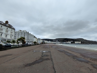

It also has a long pier but we didn’t walk out all the way as most of the shops were closed and it was super windy! It kept threatening to rain, a few sprinkles would fall and then it would stop.
We stopped for fish and chips for lunch at “Barnacles” and then went to the next down which was supposed to have an even better promenade but we didn’t think so:

We then drove up the nearby hills to check out a Bronze Age Mine but didn’t tour it:


We stopped to check out the beach promenade in Old Colwyn but were not impressed except for the many, many windmills we could see out at sea:

Gwynt y Môr (Welsh: meaning sea wind) is a 576-megawatt (MW) offshore wind farm located off the coast of Wales and is the fifth largest operating offshore windfarm in the world. The farm has 160 wind turbines of 150 metres (490 ft) tip height above mean sea level.
Enroute to our next stop was the Pont Fawr Bridge aka the “Shaking Bridge”. There was no real view point except at a café so we could only stop a moment to take this snapshot.

Pont Fawr is a steep and elegant three-arch stone bridge that crosses the Conwy River in Llanrwst, Wales. The bridge was built in 1636. The bridge is so narrow as to allow single file traffic only, thus causing many a heated argument at the top of the bridge. The bridge connects the town with Gwydir, a manor house dating from 1492, the fifteenth-century courthouse known as Tu Hwnt i’r Bont (now a popular cafe and tea rooms).Originally built to carry horses and carts, the poor old bridge now has to stand up to modern traffic and it is feared it is only a matter of time before irreversible damage is done to this jewel in the crown of the Conwy Valley. It is also known as the “Shaking Bridge”, as it vibrates if the parapet is struck above the central arch.
Our next stop after driving through more of the Snowdonia NP
was the small village of Betws-Coed which is nickname the “prettiest town in Wales”. It’s pretty touristy and we can see how it would be so pretty when spring has sprung further; it has lots of stone buildings and walls and a lovely stream running through the town


Now our plan was to do a hike in Snowdonia National Park the next day but we couldn’t find a place to spend the night that wasn’t just beside the highway. The highway is not a freeway but the speed limit is 60mph and cars just whip on by.

We decided to make our way back towards the coast to Bangor where there appeared to be a better option and IF the weather held until tomorrow, we could return as it was only 30 km / 20 miles. Well after a mapping snafu we made it to the parking at the foot of their pier and for £1.50 we got 24 hours worth of parking in a quie, not very busy lot. Just as we got parked, the rain began and the wind was viscous.
We had dinner and attempted to use the furnace to keep warm but the pilot light kept being blown out by the wind! We managed to keep just warm enough but used all our blankets were used that night! We slept pretty good.
We awoke Thursday morning to clearing skies but the wind had not let up. We figured after all that rain last night, the hike would be just a mess of mud and when Doug went out he could see snow on the nearby peaks!
We don’t have much else to see/do before we catch the ferry tomorrow but we did have a few spots to check out and two things to do.
As mentioned above, Doug’s been suffering some tennis elbow and although he’d purchased a sling several days, it’s not helping so Fran found a proper tennis elbow brace at the Boots in Bangor and we went over, parked nearby and got it. Next was getting our first UK propane tank filled; the first place we went to had no propane and we’d been told the day before at a different station fewer and fewer stations still sell it! So we went to an actual LPG place and it was easy peasy to fill, Doug check for leaks and there were none and we were good to go.
First point of interest was the Menai Bridge over to Anglesly island (where the ferry to Ireland happens to be located) – the first modern suspension bridge completed in 1826.


The Menai Suspension Bridge a suspension bridge spanning the Menai Strait between the island of Anglesey and mainland Wales. It was designed by Thomas Telford andit was the world’s first major suspension bridge. Construction of the bridge, to Telford’s design, began in 1819 with the towers on either side of the strait. These were constructed from limestone and were hollow with internal cross-walls. Then came the sixteen huge chain cables to support the 176-metre (577 ft) span, each consisting of five parallel bars of wrought iron links, for a total of 80 iron bars and 935 links per cable.
The chains were carried over the piers on cast iron saddles with rollers, allowing for movement caused by temperature changes. Each chain measured 522.3 metres (1,714 ft) and weighed 121 long tons (123 t; 136 short tons). Their suspending power was calculated at 2,016 long tons (2,048 t; 2,258 short tons). To avoid rusting between manufacture and use, the iron was soaked in linseed oil and later painted. On both sides of the river the chains were conveyed through three tunnels into a chamber cut into the rock, where they were held in place by 9 feet (2.7 m) bolts resting in cast iron sockets.. Each chain had four adjusting links so that differences in length caused by imperfections during the production of the large number of separate links could be compensated for.
Workmen assembled the majority of the chains link by link on-site. This was carried out on platforms near the tunnel mouths until the chains, supported by scaffolding, reached the tops of the piers. A cradle capable of carrying two workers was then suspended from each tower and links were lifted up and attached by the men in the cradles until the chains reached water level. The final central portion of each chain was floated across on a 400 feet (120 m) raft and lifted via a system of pulleys by 150 men. The bridge was opened to much fanfare on 30 January 1826 and reduced the 36-hour journey time from London to Holyhead by 9 hours.
We drove along the coast and could see the snowy mountains

And made our way to the pretty town of Beaumarais where we visited today’s castle:


again not going inside. The town also boasts a hotel with the largest single hinged door in the world:

It was brisk cool walk but the sun was getting stronger although not much warmer!
Final attraction of the day was the South Stack Lighthouse on the northwestern tip of the island. We got parked, paid our £2 parking fee and before going outside in the strong wind to see it, we made and had lunch.
You cannot actually go onto the lighthouse property without paying what we felt was a rather steep entry fee and we didn’t want to do that anyway but rather then hike down in this wind, we opted to see it from the road:

The coastline was beautiful and the drive towards Holyhead (where we get the ferry) was pretty. We had four possible options for parking and after some more mapping snafu’s we found a somewhat sheltered spot and chilled for the afternoon …..