February 1st, 2021
February began with a cloudy day – looked like rain but none was forecast. Doug recently began a course online: Masters Course in Geomorphic Processes. He’s quite enjoying it – takes up about four hours of his week.
Groundhog Day began cloudy and we went out for a “weekly” outing. Today we were headed to the KOFA Nature Reserve to do some off roading and a short hike.

Park map:

After picking up some breakfast we drove about 100 km / 60 mi north up the AZ95. As soon as you enter the reserve the road is dirt. There is BLM camping here and we saw a couple of dozen RV’s/vans.
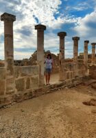
First road we took was the Palm Canyon Road; it was about 8km / 5mi to a half mile hike to see a growth of palms up high in a canyon.
As we arrived there, Fran began taking photos with her camera only to discover there was an issue with her SD card – it keeps saying “unable to read” and would not store the photo. As she carries extra batteries but not an extra card she had to resort to taking photos only with her phone. (Update: when we got back we tried another card in the camera and it worked; she tried reformatting the original to no avail – well it was about 7 years old.)


Can you make out the palm trees up in here?

We drove back a ways and then turned onto the Queen Canyon Road. This is touted as the most beautiful canyon in the reserve. It’s a 4×4 road but while not too technical, it’s definitely got some rough sections (you can tell from the videos) and you really need high clearance and to be prepared for “desert pin striping” from the close bush as there are a lot of narrow sections.
We took lots of video as photos won’t do the scenery justice.
First stop was at the “skull rock”.

Then we carried on to the end of the road enjoying the scenery, the many types of cactus and the amazing rock formations and mountains.
We saw a couple of small creatures with short busy tails and we think they were round trail ground squirrels who look like this:

These digging squirrels are found in the Sonoran desert and more active in hot weather. They frequently burrow under creosote bushes which actually helps the plant because these holes allow more water to access their roots.
At the end of the road we’d reached over 1000m / 3000’ feet in elevation.
We returned home making a pit stop at the DQ for ice cream and spent the afternoon reading before our daily dip in the hot tub.
Wednesday was quite warm again and Doug went out for his walking marathon. Fran received a package to brighten our bedroom wall:

Funny sidebar: Turned out after Fran ordered this she read the “fine print” and it was a photo of a beach we’d visited in the Seychelles back in 2014; one of our favourites too!
Not sure we’ve mentioned this before but our daughter, Serena and her boyfriend, Kurt, have been wanting to move out of Montana for more than a year and COVID put the brakes on that last spring – She had received a job offer in New Mexico in March and Kurt had a line on one for himself but it all fell through. So they’ve continued to look elsewhere and Serena has now found and accepted a job in Reno, Nevada – she will be the manager of an animal shelter and starts at the end of next month. They are going there at the end of this month to check out things and Kurt will check into jobs at the many ski resorts near Lake Tahoe – which area is supposed to have the highest concentration of ski resorts in the US – so he is optimistic. They will rent out his condo and rent a place in Reno to live. They are pretty darn excited and we happy for them.
Doug was still experiencing sensitivity in the tooth he’d had a root canal done on last month so he contacted the dentist and made a checkup appointment. She thought he might only need antibiotics but wanted to see him. Turns out he not only need antibiotics but apicoectomy surgery which they did right on the spot.
An apicoectomy is a minor surgical procedure that removes the apex, or very tip, of the tooth’s root. It is also known as root end surgery, might be necessary if an infection develops or continues after a root canal.
He came home with antibiotics and pain meds, the latter of which he did use once a day for several days.
Tuesday we did another day/road trip. It wasn’t as sunny as we’d like but it was dry and a nice temperature – up to 23C / 77F. This time we did two separate routes in one day.
Firstly, we did a drive northwest of us through the Arizona Laguna Mountains (aka Sugar Loaf Area). It was not far away but the road was way more technical than expected. The book we are using:

Advised that coming from the west and going in reverse was less difficult but it still was not easy. Off roads (for those that don’t know), are rated on a scale of 1 through 10 with one being the easiest. When we had a Jeep we never did anything rated over 7 (8 and up, you can expect vehicle damage) and with Tigger, 3 was the highest we’d go. Well, today, we expected no more than 3 but some parts were a 5! Fran did most of the driving this time until she felt uncomfortable and at one point we felt we might have to road build but made it safely. We did hear a few “clunks” and lots of desert pin striping but no flat tires or visible damage.
The scenery was quite beautiful with lots of this type of plant called an ocotillo. We’ve seen the before, usually dead, but never knew what they were called; now we do!

The Ocotillo is a desert shrub and a mainstay of Arizona desert landscaping. It is made of many spiny unbranched stems with bright orange-red flowers. The Ocotillo plant is unrivaled for its graceful form and grows best in rocky, well-drained soils. Periods of low water will push it to bloom and it can grow to 12 feet high and 10 feet wide. It is often called the ocotillo cactus, but it is not truly a cactus, although it grows in similar conditions.
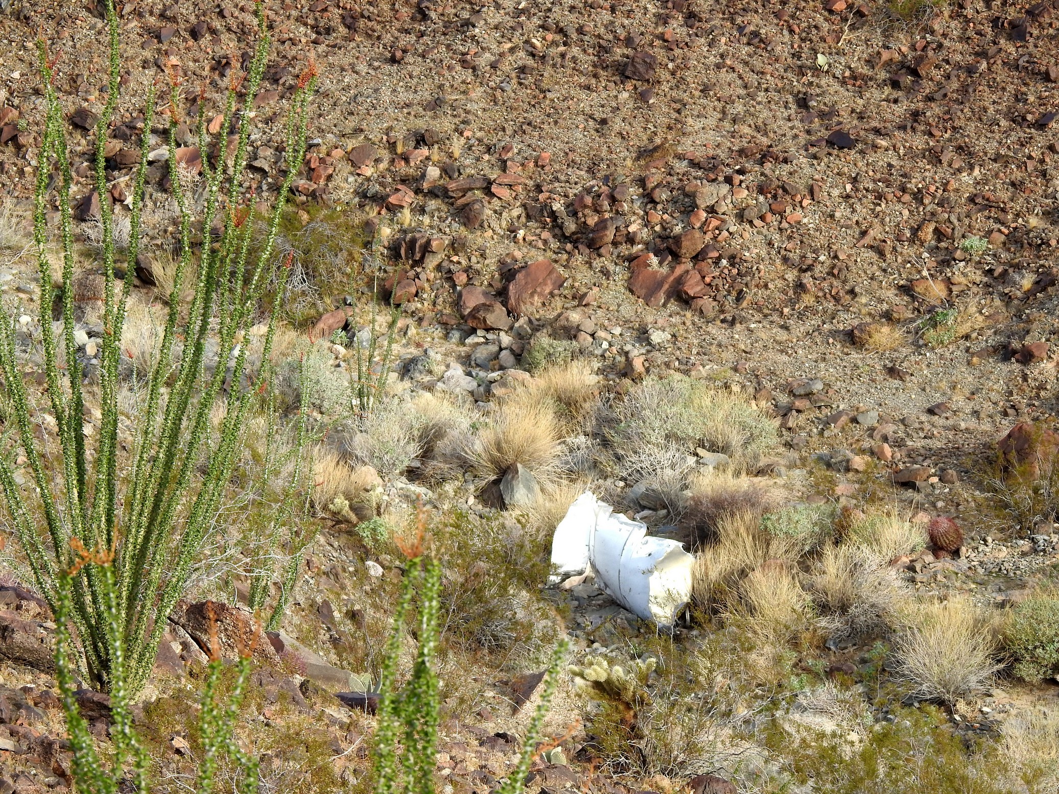
First waypoint was to view the remains of an airplane that crashed here in 1987:
We then stopped at a spot to see a few unexciting petroglyphs and some Native American sleep circles. A sleep circle is a circle of rocks, not always a complete circle where they would build a covering from twigs and sometimes their feet were left out the 4th incomplete side.
The petroglyph rock:

The sleep circle:

There was also a mine claim stake:

We stopped at a mine site but only saw mine dumps.
After some really technical sections where Doug did the driving we returned to an actual road and stopped for brunch before doing a route in the Foothills Area about 15 miles east of Araby just north of the I8.
Part of the road followed a canal, then paralleled the railroad tracks and the first stop was the former Dome train station where we looked for the remains of the adobe station but were not sure we actually found them. We were following the old Butterfield Stagecoach Road.

Then we had to go under the railway tracks (being so accustomed to driving tall Tigger, we are always leery about driving under things). After getting out of the truck, we figured we could have made it for sure but why not walk as it was not far.
This stop was the Dome Mine cemetery where we actually saw many more graves than expected and some as recent as 2020!
We drove to a spot where an old WW11 anti-aircraft camp had once been and then on through a former National Guard Rifle Range – nothing to see at the latter.

Then we had to find our way back to civilization and that proved a little harder than expected as a lot of these “tracks” are more for ATV’s but Doug got us out and we made our regular Tuesday “after a road trip” stop at the DQ drive-thru for blizzards.
Wednesday, Doug worked on improving our pole for the Wi-Fi but seems we had a wrong connector piece; thank goodness we are in a free Amazon prime trial as we could order and get it by end of day tomorrow. Then our folding foot stool we keep in the back of the truck broke and we were able to add that to the order too.
Doug was looking at a piece of moulding on the roof line and it seems we need a new strip on the door side of the trailer, so we’ve ordered that now too.
Thursday, we installed bug screens on the propane openings on the trailer – 3 spots:


Dave Brown came by today; he’s in Yuma for about a week to go to Los Algodones to get some dental work done. We hope to get together to share a beer or two and we’ve invited him to join us on next week’s day trip.
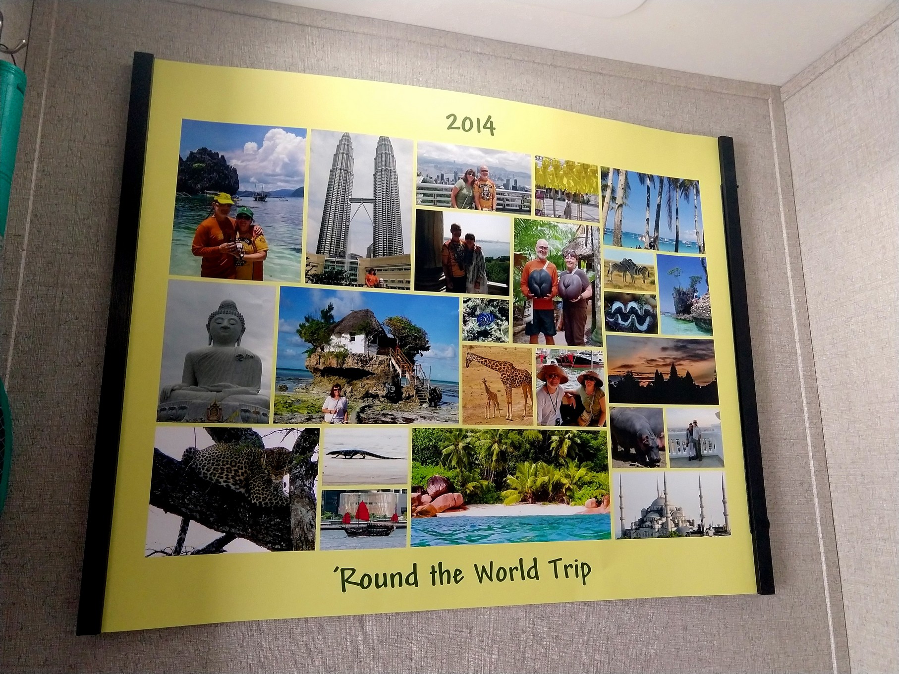
Fran made a poster on Shutterfly of a number of our photos from our Latin American adventure and we put it up right across from the front door:

Looks so good, she’s making another one of our round the world trip in 2014 to add to another wall to make the trailer feel even more like a home.
Friday the missing connector for the Wi-Fi antenna arrived and we worked on trying to get the pole up with guy ropes; not very successful so we removed them all, stored them away until we really need them and attached the pole to the awning post again – this time is a few feet higher as there is an extra piece of pole in the mix; working well now. Later that day we received the moulding to replace the roofline strip and Doug installed that quite quickly.

Dave dropped by in the late afternoon and we all chilled in the hot tub.
Saturday and Sunday were quite windy with mixed skies but no rain. We’ve decided to leave at the end of the month; have had a few queries about Tigger and hope to get it sold early next month.
Sunday, Fran noticed the “diamond” in her engagement ring has come loose again – one of the clasps seems to be too short!?; to be safe she’s put it away and will get it looked at in Mexico whenever we get there.
Monday, Fran received some sad news: her younger cousin, Elaine, lost her battle with ampullary cancer and passed away leaving her husband of 39 years, three children and three grandchildren behind. She was so very strong and courageous and will be missed by so many. Rest in peace Elaine knowing you will live on in our hearts.
Tuesday came round again and we invited Dave to join us on our weekly road day trip. This time we explored the Picacho State Recreation Area in California – about 60 km / 40 mi northwest of us. There were a few things to see, hike to and off road along.
We left around 7:30 this time as we’d read we’d need a whole day (depending how many hikes and turns offs you explore) and made our way into California taking the first exit north towards Picacho. The first 6 miles of the 24 mile road was paved, then reasonable dirt until we made the first detour to a waypoint: The Valley of Names.
Valley of Names – During WWII, soldiers who were training in the desert in this area, began decorating a site called “Graffiti Mesa” using rocks to spell out their names in the clay. The tradition continued after the war and the graffitied area grew and grew. Today it is believed over 1200 acres of land are decorated with names, messages, dates, initials and designs.

another view: 
Instead of going back out the same road to the main road, we took an alternate more rugged road back.
A couple of shots of our Tundra in action taken by Dave as he followed us:


The Spaniards probably mined gold in this area as early as 1580. Prospectors originally used the” dry placering” method because the scarcity of water did not permit regular gold panning methods. Dry placering consisted of shoveling sand and gravel onto a blanket and shaking the blanket until only the heavier gold particles remain. A “blanketful” of gold could yield over $20 in gold at 1860s prices.
The town was opened after 1852 and the gold mines expanded into hard rock quarrying by 1872. It was named Picacho (Spanish for “big peak”) after a nearby mountain of the same name. The original town site itself is beneath Imperial Reservoir, but remains of some of the ore mills are above the lake level. The site is now registered as a California Historical Landmark.
Picacho employed 700 miners at its peak from 1895 to 1900. Mill accidents, low ore quality, and the loss of cheap river transport with the building of Laguna Dam led to numerous periods of inactivity.
Upon reaching the state park, we paid our day fee and took the first right hand turn down the Railroad Canyon 4×4 road; this time Dave went first so we could take photos of him:
There were some great views at the end of this short road:


Then we made our way back out
To the main road and on to the trail head for a 4 km / 2.5 mi hike (round trip) to the stamp mill ruins


We walked past the cave used as a jail cell:


At the end we saw the remains of the stamp mill:


A stamp mill is a type of mill machine that crushes material by pounding rather than grinding, either for further processing or for extraction of metallic ores.
It was a good day for a walk, warm when there no wind but not unbearable and a good part of the hike had a lovely breeze off the Colorado River.


Upon returning to our trucks, we drove down to the riverfront and had our packed lunch:
Then it was on to check out the Picacho Cemetery:


To leave the park we wanted to take the 4×4 road called Indian Pass – it was easy to find and although touted as 4×4 only there was only one bad section as you approach the summit.

We returned to Yuma round 3, stopped for our usual DQ treat and went home.
It was nice to share this day trip with Dave even if we couldn’t be in the same vehicle.
Wednesday, Doug did his biweekly marathon walk and later in the afternoon, Dave dropped by for a relaxing hot tub with us. The weather back east has gotten quite frightful and although we’ve had some strong cool winds here and temps are not quite reaching 20C / 70F we can’t complain.
Thursday Fran learned that her mom had received her second vaccine shot and we know that Doug’s mom received recently as well.
We have both been suffering some with slow laptops and contemplating whether to buy new ones when our son, Josh, suggested just upgrading our hard drives to sold state ones. He made it sound super simple and provided Doug with instructions and a link to buy one on Amazon. Doug’s laptop has been super unbearably slow and today he tackled the removal and replacement after backing up his hard drive and reformatting with no discernible difference. The install went fast especially with a cloning wire and it opens and runs very fast now. So since that went well, Fran has ordered one for her machine that should be here on the weekend. Fingers crossed it goes just as well.

Friday we decided to take a little drive to the city of San Luis, the border town south of Yuma just to have a peek. It was larger than expected and seemed to have everything but no RV parks or campgrounds. On the way back we drove by fields of vegetables:


Saturday the weather was more back to normal and we are back to nicer temperatures in the 20’s C / up 70’s F. Life is good.
Update: we’ve now been more than two weeks without any pop in the house! We have switched to the water flavour enhancers completely and are hardly missing the soda. We allow ourselves one fountain drink a week and are pretty darn pleased with ourselves! Now the fridge has lots of cold water (and of course, beer!).

On Sunday Doug opened up Fran’s laptop to install a new SSD drive and although it was a slightly different job, he pulled it off and her laptop is also much faster now.

Later installed the vent cover over our bathroom fan that also arrived yesterday:
We were sitting outside reading in the afternoon when we could smell the aroma of a yummy barbeque. Doug wandered over after a while to see what was being cooked and met one of our neighbours, Robert, who gave him two ribs for us to taste; man, they were yummy!
On Monday Fran’s new poster with pics from our 2014 world trip when she retired and Doug went part time:
Tuesday we did our last “day trip” before leaving Yuma; today it was back into California to the area around the Salton Sea.
We left earlier than usual (7 instead of 8 as we hoped to spend some time at a hot springs or two) and made our way west then north.
The Salton Sea is a remnant of a prehistoric lake which contained a large geothermic field – there are ten geothermal energy plants out there. Decades ago, this inland lake was big holiday destination.
First stop was to see some mud volcanoes but there were “no trespassing” signs al around so we could only view from a distance
New “volcanoes” are constantly being formed. Less than 6,000 below the surface the temp is 650F to create geo thermal heat and the steam can escape through mud pools and one bubble at a time, one push of dirt at a time they create a small hill. The bubbles are caused by buildup of carbon dioxide under the earth. So in reality , they are not real volcanoes but just look like mini ones. The gas bursts can range from a quiet “burp” to a noise eruption.


At this point and all around the “sea” we are below sea level:

Enroute we spotted a flock of white pelicans but were not fast enough to get photos while driving so we grabbed this one from online:

One of the fastest disappearing species appears to the be the American White Pelican which, according to surveys, has declined from a high of 20,000 birds in 2008 to fewer than 100 now, according to aerial surveys.
Next we carried up on the eastern shore to Bombay Beach – a resort town in the early hey days of the Salton Sea area (before the pollution and salinity rates rose). There were several art installations and lots and lots of run down mobile homes:
We tried to walk out to the actual beach but first encountered this sign:

We moved further down the beach for a bit
 then it got quite mucky and we gave up.
We drove through the weird town and were glad we don’t live here:
Before stopping for breakfast we made our way to Slab City – we’d been here before back in 2001 with the kids but didn’t check out the hot spring; well when we got there we realized it was no loss:

The water was disgusting and there was NO way we were getting in that!
After breakfast we worked out way east again to try and find the hot springs outside Holtville; after a few screw-ups by the GPS we made it but the parking lot was blocked off and a big CLOSED sign was posted. However we wanted to at least see the place so we crossed the fence line and saw all the palm trees surrounding a pool:

Fran tested the water and it was cold! Then we saw a sort of fountain of water at the end and went to check that out. It was a fenced in area with an open gate and a closed sign (?). It was pretty obvious someone had been here and we walked in to test the water; it was quite warm but we didn’t feel comfortable using the place with a closed sign. While returning to the truck, Doug noticed long term BLM camping across the road and we figure they were the ones using the pools.

So back to Yuma we went, filled the tank (we got nearly 19 mpg on this little trip!), got our DQ treat and went home. While driving back, Fran was driving and Doug called Toyota to get the Tundra’s 5,000 mile checkup booked for tomorrow.
It was another quite warm day on Wednesday; Doug went for his marathon walk and Fran took the Tundra in for its checkup; all good, tires rotated and vehicle washed – all covered in the warranty.
Thursday proved to be a “blustery” day as Pooh would say; it cooled off a fair bit too although it won’t last long. We got a few chores done in preparation for leaving on Monday and the sun continues to shine…. Fran got the interior of the truck all spic and span after all the off roading we’ve done in the past month.
Friday thru Sunday we got a few things in order to get ready to leave: cleaning the solar panels, washing the awning (and in the end we just watched the whole trailer), laundry, and the like. It was lovely and warm Friday and Saturday but the cold wind returned on Sunday but it did not bring clouds.
For our own recollection down the road, Fran’s kept track of the winter daytime temps during our stay in Yuma:
|
Dec |
26 🌞 24 |
27 🌤21 |
28 🌤19 |
29 🌤 17 |
30 🌤19 |
31 🌞 20 |
|
|
|
|
|
|
|
|
|
|
|
|
|
|
|
Jan 1 🌞 20 |
2 🌞 20 |
3 🌞 21 |
4 🌞 22 |
5 🌞 23 |
6 🌤19 |
7 🌞 23 |
8 🌤23 |
9 🌞 21 |
10 🌞 23 |
|
11 🌤 21 |
12 🌞 22 |
13 🌞 23 |
14 🌞 27 |
15 🌞 27 |
16 🌞 29 |
17 🌞 28 |
18 🌞 26 |
19 🌤 21 |
20 ⛈️🌤 19 |
|
21 🌤 21 |
22 🌤19 |
23 🌤 20 |
24 🌤19 |
25 🌦 ️🌞 14 |
26 🌞 16 |
27 🌞 17 |
28 🌤 20 |
29⛈️ 🌤18 |
30 🌤19 |
|
31 🌞 21 |
|
|
|
|
|
|
|
|
|
|
|
|
|
|
|
|
|
|
|
|
|
Feb 1 ☁23 |
2 🌤 27 |
3 🌞 28 |
4 🌞 23 |
5 🌞 24 |
6 🌞 26 |
7 🌞 26 |
8 🌞 27 |
9 🌤23 |
10 🌞 25 |
|
11 🌞 25 |
12 🌤 22 |
13 🌤 24 |
14 🌤 22 |
15 🌤 22 |
16 🌞 21 |
17 🌞 20 |
18 🌞 19 |
19 🌞 23 |
20 🌞 27 |
|
21 🌞 23 |
22 🌞 27 |
23 🌞 28 |
24 🌞 28 |
25 🌞 21 |
26 🌞 23 |
27 🌞 24 |
28 🌞 19 |
|
|
|
|
|
|
|
|
|
|
|
|
|
|
Mar 1 🌞 22 |
|
|
|
|
|
|
|
|
|
ADD CALENDAR OF WEATHER