June 5th, 2024
The Northwest Territories is one of federal territories of Canada. Yellowknife is the capital, most populous community, and only city in the territory sitting the north side of Great Slave Lake. It became the territorial capital in 1967.
The name was originally descriptive, adopted by the British government during the colonial era to indicate where it lay in relation to the rest of Rupert’s Land. It has been shortened from North-Western Territory and then North-West Territories. In Inuktitut, the Northwest Territories are referred to as Nunatsiaq which translate to “beautiful land”.
The Northwest Territories, a portion of the old North-Western Territory entered the Canadian Confederation on July 15, 1870. Since then, the territory has been divided four times to create new provinces and territories or enlarge existing ones. Its current borders date from April 1, 1999, when the territory’s size was decreased again by the creation of the new territory of Nunavut. While Nunavut is mostly Arctic Tundra, the Northwest Territories has a slightly warmer climate and is both boreal forest and tundra, and its most northern regions form part of the Arctic Archipelago.
In 1670, the Hudson’s Bay Company (HBC) was formed from a royal charter, and was granted a commercial monopoly over Rupert’s Land. Present day Northwest Territories lay northwest of Rupert’s Land, and was known as the North-Western Territory. Although not formally part of Rupert’s Land, the HBC made regular use of the region as a part of its trading area. The Treaty of Utrecht saw the British become the only European power with practical access to this territory, with the French surrendering their claim to the Hudson Bay coast.
Europeans have visited the region for the purposes of fur trading, and exploration for new trade routes, including the Northwest Passage.
The Northwest Territories has the most interprovincial and inter-territorial land borders among all provinces and territories of Canada. It is bordered by the territories of Nunavut to the east and Yukon to the west, and by the provinces of British Columbia, Alberta and Saskatchewan to the south; it also touches Manitoba to the southeast at a quadripoint in the southeast.
French was made an official language in 1877 by the then-territorial government. After a lengthy and bitter debate resulting from a speech from the throne in 1888 by Lieutenant Governor Joseph Royal, the members of the time voted on more than one occasion to nullify this and make English the only language used in the assembly. After some conflict with the Confederation Government in Ottawa, and a decisive vote on January 19, 1892, the assembly members voted for an English-only territory. Currently, the Northwest Territories’ Official Languages Act recognizes the eleven official languages
The land area of the Northwest Territories is roughly equal to that of France, Portugal and Spain combined, although its overall area is even larger because of its vast lakes. In American terms, that twice the size of Texas!
Gas: anywhere from $1.62 to 2.07 a litre CAD ($4.45 to 5.69 USD a gallon)
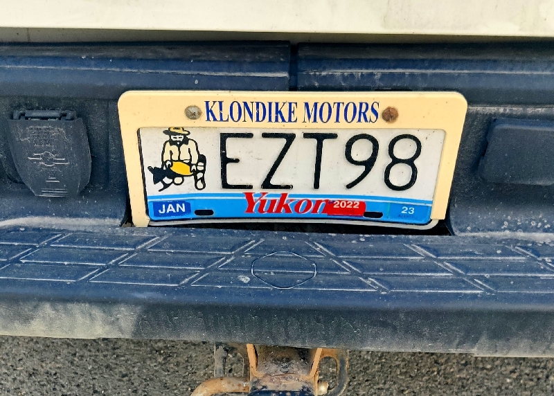
This has got to be the coolest license plate in all of Canada:

We reached the border around lunch time – we are at 60º north now!

At the the NWT sign, there is a visitor’s centre that was closed but the parking area was being used as a firefighter’s staging area. There were three helicopters, 3-4 dozen firefighters and many trucks full of gear.


We saw no flames and believed they were out there preventing spread and doing clean up.
(We did notice that the trees are not quite so tall here this far north.)
We can now saw we’ve been to ALL ten Canadian provinces and two of the three territories (when we were kids Canada only had two territories). As you cannot drive to Nunavit, we’re not sure we’ll ever get there….. but never say never, right?!
We reached the first town in the NWT – Enterprise, which was badly damaged in a fire last year and we had been told the gas station may not be operating but it was. The price was $1.91 a litre. While pumping gas, we met a ranger from the nearby Wood Buffalo National Park who confirmed that the park was been decimated in last year’s fire (we had already decided to skip going due to this) and there were few trees and no wildlife roaming around. So sad.
Wood Buffalo National Park is the largest National Park in Canada and is located in northeastern Alberta and the southern Northwest Territories and directly north of the Athabasca Oil Sands.
Larger in area than the country of Switzerland, it is the second-largest national park in the world. The park was established in 1922 to protect the world’s largest herd of free-roaming wood bison. They became hybridized after the introduction of plains bison. The population is currently estimated at 3,000 It is one of two known nesting sites of whooping cranes and the home of the world’s largest beaver dam.
The beaver dam in Wood Buffalo National Park, known as the “Lac St. Clair Beaver Dam,” is a true testament to the beavers’ determination and ingenuity. Spanning an incredible length of approximately 850 meters (2,790 feet), it is the largest beaver dam ever recorded. To put that into perspective, it’s almost three times the length of the Empire State Building!

We made a few stops along the drive to Yellowknife for waterfalls that had been recommended to us:
Alexander Falls – a short walk to the falls with a 25m / 82’ drop:

view down the gorge:

Louise Falls – an even short walk to a much shorter but triple waterfall

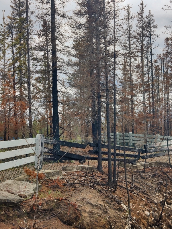
MacNallie Creek – a much burnt out area – even the posted sign was melted!


We next crossed the mighty Mackenzie River.
The Mackenzie River (means literally means great river) is a river in the Canadian boreal forest. It forms, along with the Slave, Peace, and Finlay rivers, the longest river system in Canada, and includes the second largest drainage basin of any North American river after the Mississippi.
The Mackenzie River flows through a vast, thinly populated region of forest and tundra entirely within the NWT in Canada, although its many tributaries reach into five other provinces and territories. The river’s main stem is 1,738 km / 1,080 mi long, flowing north-northwest from Great Slave Lake into the Arctic Ocean, where it forms a large delta at its mouth. Its extensive watershed drains about 20 percent of Canada. It is the largest river flowing into the Arctic from the continent, and including its tributaries has a total length of 4,241 km / 2,635 mi, making it the13th longest river system in the world.
The ultimate source of the Mackenzie River is Thutade Lake in northern British Columbia. The Mackenzie valley is believed to have been the path taken by prehistoric peoples during the initial human migration from Asia to North America over 10,000 years ago, despite sparse evidence. The Inuvialuit, Gwich’in and other Indigenous peoples lived along the river for thousands of years. The river provided the major route into Canada’s northern interior for early European explorers.


We stopped at Fort Providence for a drink and a stretch and they were making fresh popcorn which we couldn’t resist – it was around 4 and we were ready for a snack as we still had a good two hours to go.
We began to see many bison on this drive:


There was a gas station here too and the price was $2.07 a litre! We expect we’ll have to pay the piper when we leave Yellowknife to get further west and that will hurt.
By the time we reached Yellowknife (1007 km / 625 mi from Peace River), we had a pretty clear sky and the sun was up for hours! Yellowknife sits right on Great Slave Lake. While this lake is huge, the largest lake in the NWT (second in Canada) is Great Bear Lake further north and it’s the 8th largest in the world).
Great Slave Lake is depicted in a great deal of art work around Yellowknife.
Great Slave Lake is the deepest lake in North America at 614 m / 2,014’ and the tenth largest lake in the world by area. It is 469 km / 291 mi long and 20 to 203 km /12 to 126 mi wide.


We had booked a hotel through Expedia this time as nothing came up for our dates on our usual app. At 6:30 pm we checked into the Chateau Nova Inn and were given a king room with fridge, kettle, toaster, microwave, free parking and Wi-Fi for $153 CAD a night including taxes. It’s very nice, looks quite new and we got a fourth floor room with the midnight sun coming through all afternoon into the night. The sun sets at 11:25 at night and rises at 3:49 am! We’re getting up there; currently at 62º north. We are wearing eyeshades to bed at night in order to get to sleep and then STAY asleep.
We had a nice cold beer for happy hour to celebrate after our long day of driving (we had stocked up before crossing the border into Canada) then made dinner in our room (salad, yoghurt and sandwiches) and had a quiet night. It’s surprising how warm the hotel rooms are. We’ve had to turn on AC in order to sleep in every place we’ve stayed in since MN!
Wildlife tally: 1 bear, 5 deer – all in Alberta before we crossed into the NWT. (no photos)
We awoke the next morning to mostly cloudy skies and spent some time online getting things done while it “warmed up” a bit. The high was only going to be 12C / 54F today.
Around 10:30 am we ventured out and it was not too bad; we worn fleece vests and jackets – Doug brought gloves; Fran brought a scarf.
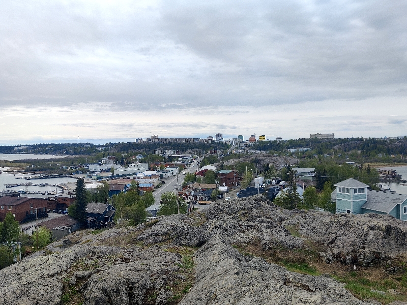
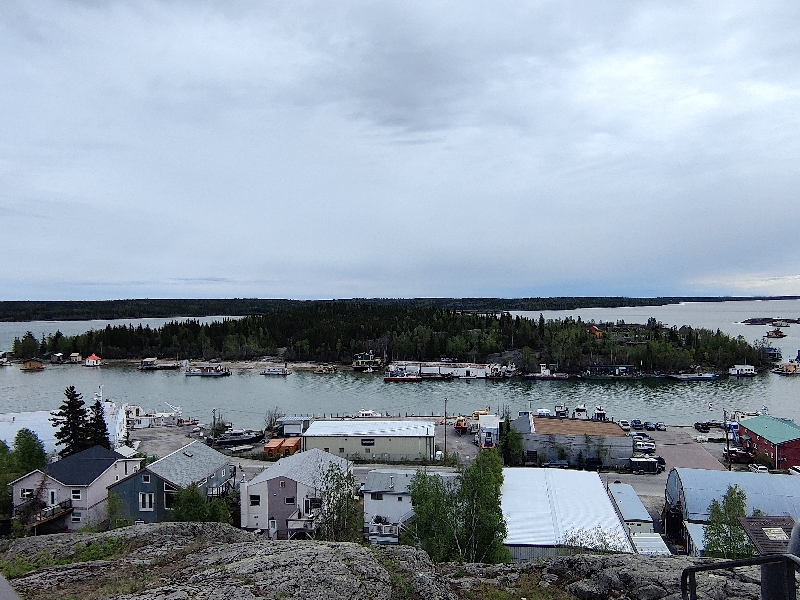
We walked to the further point first on our list: Back Water Bay lookout; the route took us through a new subdivision into the bush and up onto the rocks for a view over Great Slave Lake and Old Town Yellowknife:


We walked back down the rocks and then into town to go find the famous “Wildcat Café” for lunch but it was closed for lunch. We’ll see about making a reservation for tomorrow night.

We checked out what is like a general store, Weaver and Dorve – not impressed. Then found Bullocks Bistro for lunch. It was kinda of local funky place with graffiti and stickers all over the ceiling and walls inside.

After sharing an expensive dish of seared Arctic Char (it was very good!), fries and salad with a pop each ($43!), we walked over to the ice pilot’s memorial up on the high point of the city:


We strolled over the boat launch and Fran dipped her toe into the Great Slave Lake.

We saw the heritage & cultural centre display at what they called the “crossroads”:

We then walked down to the main street past “Ragged Ass Road” into the newer part of town back towards our hotel stopping for some groceries.

Friday started very wet – it had begun raining last night and continued until mid morning. Doug went for his long run today (when it stopped) as we’ll be driving most of the next few days having to do a lot of miles between lodgings. It’s cold again today too – high’s only reached 10C / 50 F.
After lunch in our room, (we have a toaster so we made use of it!) we drove over to see the Legislative buildings of the NWT but it was all hidden behind trees (turns out it’s best viewed from the back) so we got this photo off Google.

Then we continued down the same road to the Prince of Wales Northern Heritage Centre. This is a pretty well done museum about the history and life in the NWT. We spent a good hour here at this free museum.

In 1972, a program calling for the development of museum services in the the NWT received official approval from the Government of the Northwest Territories. Construction started in 1975. On April 3, 1979 His Royal Highness, Prince Charles, Prince of Wales, officiated at the opening of the facility that bears his name. The PWNHC acquires and manages objects and archival materials that represent the cultures and history of the Northwest Territories (the NWT), plays a primary role in documenting and providing information about the cultures and history of the the NWT, and provides a professional museum, archives and cultural resource management services to partner organizations.
There were several galleries including geology, history, lifestyle and a very good one on the animals of the territory.


The oldest rock on the planet was discovered in the NWT. It’s over four billion (4,000,000,000!) years old:

A fifty million year old chunk of wood is also on display:

How Yellowknife got its name:

Then we went to fill up the car (at $1.62 a litre plus Fran had a $20 off coupon for the Shell so that helped a lot) so we’re ready for tomorrow before returning to the hotel for some chill time before dinner. At 5:30 we drove up to the Wildcat Café hoping to get in – they don’t take reservations. Turned out to be a non-issue despite it not being all that large (and the fact that it was raining outside meant no one could sit on the patio), we got a table no problem. The building looks old from the outside but it’s nothing all that interesting inside – just like being inside a log cabin. The tables are bench style and the inside part probably seats a couple of dozen. The menu was small with some interesting items on: “klik” we were told was a like a Canadian version of “spam”, seal sausage roll, bison meatloaf, smoked fish croquettes and more. Doug had the bison and Fran had the croquettes and we shared sides of broccoli and baby potatoes (super yummy – boiled in lemon water and then fried!).
We chatted with two young women who sat beside us at the long table; both were locals living and working in Yellowknife. One was the great niece of a woman who once ran the “ferrying service” between the city and the nearby Latham Island – it was a row boat and the crossing cost ten cents!
After dinner we drove over to Latham Island – seems to be just residential homes. We returned to the hotel and had an early night since we wanted to hit the road early tomorrow.
Neither of us slept well and we were up just before six a.m. We wanted to take the “short cut” from here to Fort Liard – it’s nearly 800 km / 500 mi and over half is on gravel road – this allows you to save 600 km / 400 mi of driving. We stopped to fill up again in two hours at that expensive filling station we’d see a couple of days ago at $2.07 a litre – OUCH! There would be no gas for another 550 km so we needed to top up.
Shortly after crossing the Mackenzie we were back on Highway 1 and heading west. About 50 km / 30 mi later we hit the dirt road. Turned out not to be gravel but it was quite full of small (and the odd large) pothole and it was quite wet so it was very muddy.
We stopped to see the Sambee Deh Falls:


At one point a tracker trailer truck went by us and a lot of small rocks flew – several hit the car and one put a small visible chip in the windshield.

The dirt road lasted 144 km / 89 mi then it was 37 km / 22 mi of pavement before dirt again for 235 km /146 mi. Then we turned onto the Highway 7 south towards the provincial border with British Columbia (Fort Liard is about 40 km / 25 miles north of it) and that road was more hard pack and mostly dry. The Civic did very well and we did not have any issues today. We still have lots of dirt roads to do further north but we made it this far.

The scenery didn’t change much on the drive: forest and burnt forest with many small bodies of water for about half the drive.

We filled up the car with gas in Fort Liard at the only station in town before checking in at $1.74 a litre so we’re good for the morning – another long driving day.

Accommodations that are not camping are scarce so Fran had phoned a couple of days ago and booked the only motel on this route. We arrived here around 4pm, got checked in and paid the hefty $236 CAD price for a motel room with no Wi-Fi but a TV so we could watch tonight’s Game 1 of the playoffs, a fridge, microwave, coffee maker and free parking right outside the room. It’s not fancy (nor is it worth $236) but it’s clean and there are two beds, with a small table and chairs. It will do the job.
We relaxed before dinner, made sandwiches for dinner and watched the hockey game after dinner. Sadly the Oilers lost 3-0 with the final goal on an empty net.
Wildlife tally today: 1 rabbit, 1 fox, 1 mama bear with two cubs, 1 single bear, (both times far away) lots and lots of bison, some solo some in herds.


We are so grateful today went without a hitch. (First of 7 non paved sections of road we need to travel on.)
After a quiet night in Fort Liard, we awoke to full sunshine and we hit the road again around 6:30. Before we hit the BC border, it clouded over and we began to smell and see smoke again for several kilometres. Today we had about 28 km / 17 mi of dirt road, then glorious pavement the last 20 km / 12 mi in the NWT all the way to Watson Lake (although to be honest, there were a few gravel sections where repair work was being done.

Just before leaving the NWT and entering northern British Columbia (BC), we came upon a single bison:

Welcome sign into BC:

Upon reaching the actual Alaska Highway north of Fort Nelson (about 140 km / 86 mi from the border), it was quite cloudy but stayed dry. Doug found a Alcan (Alaska / Canada highway) mile marker website enroute and although we stopped at most of these spots when we went to Alaska in 2012, we did repeat two stops today.
After passing Summit Lake, the highest point on the Alcan, (1244 m / 4081 ‘) the sun was out in full force once again and it made for a spectacular drive.
We saw a porcupine on the side of the road and watched it climb up the other side of the ditch:

Dall sheep were at Stone Mountain where we knew we’d seen them in 2012 (and two more later on down the highway).


And finally, a moose, although it was pretty skittish, so we didn’t get to snap a pic.
There was the odd bison and at one point we saw a herd in a meadow but there were already plenty of vehicles stopped to look at them so not a great deal of side of the road room.
Later on we passed by a black bear but didn’t stop as there was a vehicle already stopped and we were going quite fast at that point so we didn’t want to scare it off for the spectators.
We saw another rabbit today and a small black critter without a tail (maybe a lemming?) raced across the road at one point.
First stop in BC was Liard Hot Springs – we couldn’t resist!. The parking lot was not very full and after paying our entry fee ($6 a car) and renting a towel ($4), we walked the boardwalk to the springs. Other than a couple of new buildings, they hadn’t changed a bit.


At Muncho Lake, the scenery was as grand as we remembered and we stopped for pics enroute and at a viewpoint.


To get to our hotel that we booked for tonight, we had to get into the Yukon. The Alcan crosses the provincial/territorial border a couple of times before reaching Watson Lake. The weather was fantastic and reached up into the high 15 C / 50’s F. Upon arriving, the first order of business was a car wash as the Civic was so dirty we hated to touch it. But first we stopped at the Watson Lake Sign Forest.
In 1942, a simple sign post pointing out the distances to various points along the tote road being built was damaged by a bulldozer. Private Carl K. Lindley, serving with the 341st Engineers, was ordered to repair the sign, and decided to personalize the job by adding a sign pointing towards his home town, Danville, Illinois, and giving the distance to it. Several other people added directions to their home towns, and the idea has been snowballing ever since. The Sign Post Forest is a collection of signs at Watson Lake, Yukon and is one of the most famous of the landmarks along the Alaska Highway. Visitors may add their own signs to the more than 100,000 already present.


We found the sign we’d left there 12 years ago right where we left it but the little “Tigger” sticker we’d stuck on it was gone – just a shadow on the sign.

After a few tries, we found a self-serve car wash and cleaned all the mud and dust off.
 After driving away from there, we felt a weird shudder sensation enroute to getting gas. Doug thought maybe the car just needed to have the brakes applied quickly a few times but that did nothing. After a bit of research while we were driving back to the gas station to have a mechanic look at it, he discovered it could be dirt in the wheel well. We got out and looked and one wheel well was still quite caked in thick dry mud so we were turned to the car wash and clean all four wheels wells more thoroughly and that did the trick. Phew!
We got to the hotel we’d booked by phone called The Air Force Lodge.

The Historic Air Force Lodge is the oldest building in the small northern community of Watson Lake, Yukon. It is a heritage structure that has quickly become one of the most attractive and affordable stops along the Alaska Highway. Originally built at the Watson Lake Airport 1942 as a barracks for the pilots flying during Second World War, it was later moved to the town where it stood empty for many years. Then in 1998 the present owner completely and thoroughly refurbished the interior while leaving the exterior structure in its original form. Over the period of two and a half years of pains taking and meticulous craftsmanship the interior became a visitor’s lodge still very true to its wartime functional purpose of barracks, but with many modern features that surpass the highest building standards. The Air Force Lodge is completely non smoking and very clean.
Mike and Claudia, a German couple, are the owners. The rooms are decent sizes and we had a king bed with a desk, tv and closet area. There are no private bathrooms (that part we didn’t know about when booking). They let us use their fridge to refreeze our ice packs and lent us two to use overnight.
Today’s wildlife tally: the dahl sheep above, a bone bear in the distance and a porcupine:

After a quiet night (Fran had to use the fan as there was no AC and it didn’t cool off all that much overnight), we did our usual morning routine and left the hotel around 8:15 am. We were headed to Whitehorse today – the capital of the Yukon. “Larger than Life” is the territory’s slogan. This is their license plate:
The day started out cloudy but cleared up by mid-morning and it was another beautiful scenic drive.
Today we made a couple of stops: first was the Rancheria Falls where we took a short walk to see the double set of water falls.


There was a flat section of trail then a raised boardwalk – all accessible.
After a few animal sightings we stopped at Johnson Crossing (as we had done back in 2012) to enjoy a warm cinnamon bun – it was as good as we remembered and way better than a sugary Cinnabon one.

The rest of the drive was lovely but no further stops except for breaks.
We drove along the mighty Yukon River:

We arrived in Whitehorse (just above 60º N again) around 2, stopped for gas (at $1.90 CAD a litre) and a bit of groceries and checked into the Town and Mountain Hotel downtown. It’s an older hotel but still decent. We got a king room with fridge and microwave for $170 CAD. After lugging everything up to the third floor, Fran went for a walk and hit an ATM and walked around downtown.


We’re now on Pacific time so tonight’s Game 2 of the Stanley Cup started at 5pm so we watched in our room making dinner between periods. Very unfortunately, Edmonton lost again!
The days are long here in Whitehorse with the sun setting at 11:30 and rising at 4:30.
Wildlife tally:
2 bears – but photo only of one

1 porcupine
We left Whitehorse early on Tuesday to make the drive further north to Dawson city (64ºN) – this too is a place we visited back in 2012 but wanted to come here for 3 reasons: 1) it’s the closet place with hotels to the start of the Dempster Highway; 2) they have an Info Centre about the Dempster Highway and 3) Fran wanted to do the “SourToe Cocktail” that she didn’t do back in 2012.
You turn off the Alaska Highway onto the Klondike Highway to head further north. Not too far up the highway, we saw a large unimog type rig that was broken down right in the right hand lane with emergency triangles set out. We stopped in front of them to see if they needed help and met Rhonda and Jeff from Texas who were having an electrical issue which Jeff think he got sorted out. They had spent the night parked right there and actually had a grizzly come by!
When we reached the village of Carmacks, we saw gas at $1.99 and figured it might be worse further north, so we topped up. (It wasn’t!)
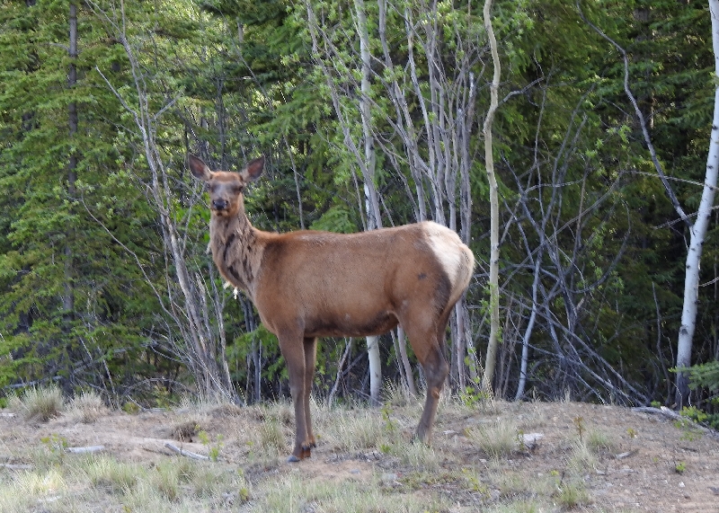
Before we stopped at Braeburn Lodge, we encountered two elk on the road side:

This lodge was a place we’d had huge cinnamon rolls the size of dinner plates back in 2012 but their oven was broken so they had none. Shame.
Later we stopped at the Pelly Crossing at a viewpoint for the views:


At lunch time we stopped at Stewart’s Crossing to eat and met a young French couple, Lorenzo and Laurie, who had flown to Seattle, gotten a camper (we weren’t sure if they were renting or what) and they were headed to Anchorage with it to drop it off. We chatted for a while, took a selfie and discussed meeting up in Dawson city.

We got a hotel about 3km /2 mi outside of town (a huge motel/RV park) as it was way cheaper than in town itself. We got a room with two double beds, private bath, Wi-Fi (slow) and a fridge/microwave for $159 CAD at the Bonanza Gold Motel.
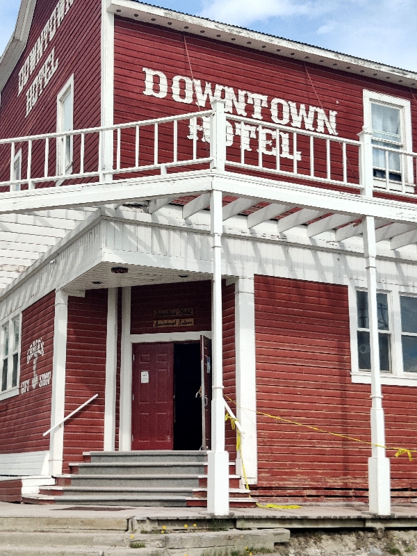
Dawson City is a cool little town which has retained its roots as a Klondike Gold Rush town – colourful 19th century buildings, wooden sidewalks and dirt streets.
Fran had read online that the “Sourdough Saloon” opened at 4; nope; it was 5 so we went for a walk and then went to get gas ($1.87 near the hotel). We returned to find it open but they don’t do the “toe ceremony” until 6! We left and then after finding and chatting with Lorenzo and Laurie (they weren’t going to join us as they wanted to take the ferry and get into Alaska tonight), we returned to the bar and had a beer. Fran signed up for the SourToe cocktail and she was the first up at six.
Doug filmed it and she took the shot of Yukon Jack whiskey with the “toe”. It has to touch your lips and you are not allowed to let it touch your teeth, go into your mouth or swallow (as if!).
The legend of the first “sourtoe” dates back to the 1920’s and features a feisty rum-runner named Louie Linken and his brother Otto. During one of their cross-border deliveries, they ran into an awful blizzard. In an effort to help direct his dog team, Louie stepped off the sled and into some icy overflow—soaking his foot thoroughly.
Fearing that the police were on their trail, they continued on their journey. Unfortunately, the prolonged exposure to the cold caused Louie’s big toe to be frozen solid. To prevent gangrene, the faithful Otto performed the amputation using a woodcutting axe (and some over proof rum for anesthesia). To commemorate this moment, the brothers preserved the toe in a jar of alcohol.
Years later, while cleaning out an abandoned cabin, the toe was discovered by Captain Dick Stevenson. After conferring with friends, the Sourtoe Cocktail Club was established and the rules developed. Since its inception, the club has acquired (by donation) over 25 toes.


Today we saw not only boreal forest but lots and lots of birch trees.
Canada’s boreal forest (270 million hectares) stores carbon, purifies the air and water, and regulates the climate. Because a large portion of the world’s boreal zone lies in Canada (28% or 552 million hectares), this country’s boreal forest affects the health of the environment worldwide.
It is a vast region comprising about one third of the circumpolar boreal forest that rings the Northern Hemisphere, mostly north of the 50 parallel. The boreal region in Canada covers almost 60% of the country’s land area. The Canadian boreal region spans the landscape from the most easterly part of the province of Newfoundland and Labrador to the border between the far northern Yukon and Alaska. The area is dominated by coniferous forests, particularly spruce, interspersed with vast wetlands, mostly bogs and fens. The boreal forest zone consists of closed-crown conifer forests with a conspicuous deciduous element. The proportions of the dominant conifers (white and black spruces, jack pine, tamarack, and balsam fir.
The boreal region contains about 13% of Canada’s population. With its sheer vastness and forest cover, the boreal makes an important contribution to the rural and aboriginal economies of Canada, primarily through resource industries, recreation, hunting, fishing and eco-tourism. Hundreds of cities and towns within its territory derive at least 20% of their economic activity from the forest, mainly from industries like forest products, mining, oil and gas and tourism. The boreal forest also plays an iconic role in Canada’s history, economic and social development and the arts.
Today’s wildlife tally: 1 bear, 2 elk