

August 28th, 2019
Brazil – the largest country in South America borders every country on the continent except Ecuador and Colombia; it’s the fifth largest in the world as well as the fifth most populated. Its capital is Brasilia and its largest city is São Paolo. It has 26 states and one federal district. It is one of the most multicultural and ethnically diverse nations, due to over a century of mass immigration from around the world.
The land now called Brazil was claimed for the Portuguese Empire in 1500, with the arrival of the Portuguese fleet. The Portuguese encountered indigenous peoples divided into several tribes, most of whom spoke languages of the Tupi-Guarani family and fought amoungst themselves. Though the first settlement was founded in 1532, colonization did not begin until 1534, when King John of Portugal divided the territory into the fifteen private and autonomous colonies; that proved dysfunctional and they were reunited as one colony in 1549. Brazil gained independence in 1822.
Brazil, like most Latin American countries has had a contemptuous history with various dictatorships, poor presidents, bad economies and hyperinflation. Finally in 1994, Fernando Cardoso was elected president after being Minister of Finance in the previous administration when he produced a highly successful economic plan that, after decades of failed economic schemes made by previous governments attempting to curb hyperinflation, finally stabilized the Brazilian economy.
The peaceful transition of power from Cardoso to his main opposition leader in 2002 was seen as proof that Brazil had achieved a long-sought political stability. However, sparked by indignation and frustrations accumulated over decades from corruption, police brutality, inefficiencies of the political establishment and public service, several protests erupted in Brazil from the middle of first term of Dilman Rousseff who was elected in 2010. She was finally impeached in 2016 and in 2017 the Supreme Court asked for the investigation of 71 Brazilian lawmakers and nine ministers in the cabinet ( of President Michel Temer) who were allegedly linked to the Petrobras corruption scandal including the President. In 2018, 62% of the population on a poll claimed that corruption was Brazil’s biggest problem.
The currency of Brazil is the real and there are more or less 4 reals to a USD (three to the Canadian dollar). The price of gasoline is about 4.5 reals a litre ($1.14 USD/$1.50 CAD) so that’s about $4.30 a gallon but fluctuates and we’ve seen it as low as 3.99 and as high as 4.69! The most popular beers in Brazil are Antarctica, Cacado and Bohemia Weiss (none of which we’ve tried yet).
Now as we mentioned in the last posting, we had so much time in Asunción, Paraguay before our flights “home”, we looked at our options for how to spend that time. There is not a lot in this area (we didn’t want to do an out and back to the east as we’re heading that way in October) and Brazil is a HUGE country. Our route did not include doing a great deal in the centre of Brazil and there were a couple of state/national parks we were interested in checking out. Brasilia is the closest major airport to these parks and could prove to be an interesting site in itself, but we didn’t feel it was worth the detour so far inland to just to check the city out while overlanding.
So… we decided to fly into Brasilia for ten days and do a car road trip. Doug found us points flights on our credit card and we arranged a rental car and a hotel stay for the first night. We’ll wing the rest as we travel.
Sebastian at Quinta Tiffany, offers long term parking of rigs for about $1.50 a day and provides transportation to and from the airport and as he’s only about 4 km away from the there.
He took us to the airport at 8:30 on Wednesday morning and our flights to Brasilia via São Paulo went smoothly. Before leaving Paraguay, we decided to try and use our American passports to enter Brazil this time hoping that would save us these 11 days on our Canadian passports for when we return to this country in January – only time will tell.
After much frustration with poor signage in the airport and an unhelpful woman at the car rental desk, we found the shuttle to the Alamo office. There it was an adventure in a foreign land – the language barrier was quite apparent and no one there spoke any English or Spanish. The clerk tried hard using Google Translate on her phone and finally, after trying unsuccessfully to decipher something on the rental contract, which despite being in English, the parts filled in on it were done so in Portuguese! – they let us leave without initialing the section we couldn’t make sense of. We drove to our hotel, stopping for some takeout food for dinner and relaxed.
Our rental car was a charcoal grey Nissan Versa four door sedan with AC but no cruise control.

The good thing about it though was that it took gasoline OR ethanol and the latter is much cheaper, around 3 reals per litre.
Next morning after the included breakfast at the hotel, Doug went out to find plug adapters (the one we brought didn’t work!) and some provisions then we began to make our way northwest. Our destination was the Jalapão State Park, famous for its sunsets at the dunes, “boiling waters” and many waterfalls. We don’t like to do out and back routes so we opted to make this entire trip a circle – it meant a bit further in distance but no backtracking. As this was going to be over 900 km / 560 mi to the west side of the park, we broke it into two days.
Thursday we just drove and drove with hundreds of large double trailer tractor trailer trucks on the highways (lucky not a mountain road and lots of passing opportunities), and made it to a small city called Gurupi where we found a hotel with AC, Wi-Fi, breakfast and free parking. We didn’t see much wildlife other than a couple of rheas on the side of the road and more than a couple of dead giant anteaters. 🙁
Next morning we continued on to the town of Ponte Alta which is near a cool little canyon called Sussuapara. We wanted to check in town for tourist info for details on the roads to the site and beyond to the park but there was no such thing so without signage to the canyon, we followed our maps.me app and it turned out this was also the road to the first site in the state park.
Well as soon as you leave town, the road turns to red dirt with gravel, lots of ruts, the worst washboard we’ve ever encountered on our entire PanAm journey and sand. Thank goodness a car handles washboard better than Tigger does!
We made it to Sussuapara canyon without too much difficulty and it was worth the drive.


We then began the drive to a famous waterfall called Cachoeira de Velha – supposed to be a horseshoe shape with crystal clear water. We spotted a few blue and gold macaws but naturally as soon as you stop the engine, they fly off.

Well, after 55 km/ 34 mi down this road we had to stop. The rental car was already being pushed past its limits in the sand and finally we came upon a really deep section that was unpassable for it. Shame that no road info about this part of the country was available, even online when we researched the park. So we drove back into Ponte Alta, found a hotel with the amenities we wanted (it was right on the river) and spoke to the manager about tours.

So he had a guide come and speak with us through Google Translate on a phone and he wanted too much for his tours to the things we wanted to see so we looked to see how we could possibly drive to the eastern entrance of the park where there is a small town closer to the dunes and boilers and inquire there about tours into the park as it was much closer.
Living at this Pousada was a talking parrot:

Fran heard him say “Hello, how are you?” so she grabbed the camera but then he wouldn’t speak any more English:
The route to the east proved to be a long way around of over 550 km / 340 mi with 149 km of dirt at the end. We decided to go for it as it was in the direction of the next park we wanted to visit anyway but we needed to do two things: 1 – check out a nearby lake first and 2 – ask as we got closer about road conditions.
We left after breakfast after being told by three different people that our car would make it to Lagoa Japonês. It was about 33 km / 20 mi from the nearby town of Pindorama – where we got gas and asked different men. About 19 km down the road you get to a turnoff that says 12 or 15km (?) to the lake. We take the turn and it’s rough road but we continue (it’s not our car, right!) but 7 km / 4 mi before we get there, we reach this:

Doug gets out checking the depth and thinks we shouldn’t chance it. Just then a pick up comes along and goes through the stream so we watch his tires. It might not be too deep for us, but there are lots of rocks that we could either hit or slip off of so we abort the plan and turn around. Frustrating!
We make our way back to the main dirt road and head south to the highway. Down the highway we stop at a truck stop; here’s where we have to decide are we going north to Jalapão or south to the other park. After speaking with two truckers who deem the road passable in a car, we go for it – hey, we’ve got time.
It’s now early afternoon and our GPS says we’ll be there by 4:30 but maps.me (which is better at gauging time on dirt roads) says 7:10 – we don’t want to drive on dirt roads after the sun goes down. So Fran takes the car to warp speed and off we go as far as we can on pavement to the beginning of the dirt road so we can have more daylight time. She gains us a half hour and when we hit the dirt, she’s not comfortable going very fast on this road so we switch drivers. The road is of varying surfaces: hardpack, hardpack with bad potholes, washboard, gravel and lots of sand especially near a large dry river bed. Doug puts his 4×4 skills to the test and we make it to Mateiros before 5 o’clock.
Enroute we saw several small fires:

We couldn’t find the hotel we were looking for but found another that offers the same amenities for a tad more $$ but take it anyway. Bibi, the older lady that runs us finds us a contact to rent a 4×4 truck from to do the park; turns out the price was not for a just a truck rental (you can’t rent one on your own here) but for a truck and a driver/guide – who only speaks Portuguese. He quoted us a few prices based on destinations and we chose what we wanted.
We wandered the tiny village (didn’t take long) and stopped in the park at a kiosk for burgers for dinner. She didn’t serve beer but told us to the walk to the shop a half block away and get some cold beer. Fran did that, got four Stellas and the woman offered to keep two cold in her freezer for us while we waited for our food. So very thoughtful.
Next morning after breakfast, Juzi picked us up at 8:00 and off we went struggling with conversation. We find that often if you just keep speaking Spanish they get what you are saying, but that only works about 80% of the time and we get what they are saying about 25% of the time! If we see written Portuguese, it’s much easier.
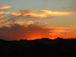
The itinerary today was to visit four “fervedouras” (bubbling waters/boiling waters/boilers), a waterfall, have lunch (on our dime) and finish the day at the dunes to watch the sun set.
A fervedoura spring is a really cool place which is turquoise hole with white sand on the bottom surrounded by banana trees. The karst spring wells up from below the sand and is fed by a cave stream. The blue colour is a typical result of the high limestone content.
The water pressure that rises from the bottom up will not let you sink. You can try, but you won’t be able to stay down. It is the effect of the resurgence. The production is so high that the swimmers are not able to stand on the bottom for long, as the sand is in a continuous state of floating. It feels like quick sand!
There are over 100 “boilers” in this area but less than ten are open to the public. To protect the pools, there are regulations like no sunscreen or bug repellent can be worn.
Well after we paid to see the Fervedoura Buritis and figured the other three would be similar we told Juzi that we wanted to only visit one more (they were $5 a person each as they are all privately owned and not actually part of the park) which we’d read good things about. Here we stepped into the water but did not go for a swim.


Fervedoura Ceiça was really cool. These pools are small and this one has “rules” – only 6 people at a time and for max 15 minutes. As there were already six people there we had to wait. When they were called out we could change and get our time. Luckily for us, only one other couple was there at the same time and no one was waiting so as the two guides chatted with the attendant, they either forgot about the time or didn’t care since no one was waiting but we had at least 25 minutes in the water. Unfortunately, we did not bring our waterproof camera and we didn’t want to risk taking a phone or the Nikon too close to the water so not many pictures.

The sensation of floating was really not that great but the cool part was not being able to stand for long without beginning to sink.
Since we did not want to visit two more pools, Juzi suggested going to the waterfall, then lunch and returning to the hotel for two hours before heading to the dunes.
So off we went to Cachoeria da Formiga (ant waterfall!). This is a beautiful spot:


Here we swam for quite a while enjoying the water and the setting. Juzi joined us for a quick swim as well before we dried off and changed. We sat in the little restaurant for a cold one before setting off to the village of Mumbuca for lunch.
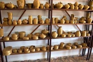
This town is an Afro-Brazilian town populated by families of former slaves. The community offers a few buffets style restaurants and souvenir shops for tourists.

Much of their crafts are made from a type of “golden grass”

Syngonanthus nitens is a grass-like plant which grows in Jalapão, in the state of Tocantins, Brazil – the region is part of the Brazilian cerrado. Its main characteristic is the bright and gold color, hence their common name “capim dourado”, which literally means “golden grass”.
The making of handicrafts began in Jalapão, in the Afro-Brazilian community of Mumbuca. Indigenous people, probably from the Xerente ethnic group, taught the art to local inhabitants when passing through the region around the 1930s. The handicrafts are made of coils of the grass sewn tightly together with strips from the leaf of a palm tree. For decades the handicrafts were only made by women for household uses and/or sporadic selling. Today, there are at least 12 local community associations.
The “golden grass’s” flowering starts in July and seeds are produced from the beginning of September through October. The Tocantins State Government, through its Environmental Agency, established a regional law allowing harvesting only after September 20, and requiring flowerhead cutting and dispersal in the grassland areas just after harvesting.

As we live in a very small space we didn’t buy anything but it was nice to browse.
After lunch we returned to the hotel until 3:30 when our driver picked us up again. It took over an hour to reach the entrance to the dunes down the dirt road and then it was 5 km / 3 mi in mostly sand and some pretty deep, to the parking area.
 Then you walk about 300 m to a stream crossing before climbing the dune up a designated pathway.
 We certainly were not the only ones there on a Sunday evening, but it was not overcrowded.
Sadly, there was a lot of smoke in the sky

Although it was mostly on north of the dunes but the clouds settled in over the horizon and the sunset was rather underwhelming.

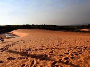

You have to be out of the park by 6:30 so you are not driving that super sandy road in the dark so a couple of minutes after the sun went down, you leave the dunes, head back to your vehicle and head back to town.
So Monday morning, Bibi, the hotel owner, got us an early breakfast at 6:30 and we drove back down the 149 km / 92 mi of dirt road before the sand got too hot (easier to drive in when it’s cool). We stopped to fill the tank, air up the tires a bit and get a car wash – we didn’t want evidence of our driving up here on the car and it was quite filthy!

We drove 510 km / 316 mi to São Jorge, a small town at the entrance to the Chapada dos Veadeiros National Park.
A toucan flew past welcoming us:

This park is made up of what is known as Brazilian “cerrado” . It is second in size only to the Amazonia region and covers 22% of Brazil. The cerrado contains different types of vegetation and is characterized by the presence of twisted short trees with thick bark and leathery leaves often surrounded by grass. The area contains a wide variety of fauna as well including jaguars, pumas, foxes, wolves, raccoons, deer, anteaters, armadillos, tapir and more. (Sadly we saw know of these!)
We drove straight to the park’s visitor’s centre to find out about hiking.

We then found a “pousada” (inn) and booked two nights.


Tuesday morning we were up to get to the park when it opened at 8, paid our entry fee, got our tickets (they limit the number of hikers on each trail) and began the waterfalls hike. This is an 11 km round trip hike in the blazing sun most of the way. There are two main attractions on this hike being two waterfalls of 80 m and 120 m in height.


As we began the hike, Fran twisted her ankle on the way down and when we began to go back up, Fran was struggling from some ankle pain, not being in shape and the extreme heat. She was seeing stars at times and her heart and head were pounding. When we got to the point where you can visit two lesser falls, we opted to return instead. At the point on the trail where you can decided between the waterfalls hike and the canyon hike, Doug left Fran to return to the car and he opted to do the other hike. That was around noon – Doug got back to the hotel at 1:30 and had completed the canyon hike:


We spent the afternoon in the town and in our air conditioned room! We left on Wednesday morning and began the drive back to Brasilia with two stops on our way out of São Jorge:
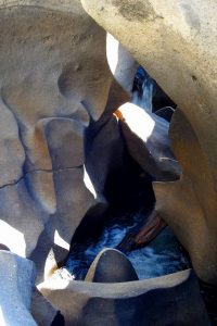
- Valley of the Moon – a short hike to some cool rock formations that reminded us of the Sooke pot holes in Canada, the Bourkes Luck potholes in South Africa and Cano Cristales in Colombia (without the colours at the latter):


2. Fazenda São Benito where there are three waterfalls:
São Benito – down a 300 m path
Almécegas I – down an 840 m trail

Almécegas II – down a 360 m trail


We completed the drive to an AirBNB in Brasilia by 3 pm and settled in for three nights. Being in a large city with lots of foreign government embassies, we figured there’d be movies either in English with Portuguese subtitles or vice versa. Doug checked and we decided to do dinner at the movies and went to see “Once upon a time in Hollywood”. Not really our cup of tea in the end but we always love going to the theatre.
Thursday, we spend the majority of the day in the city of Brasilia.
Brasilia is located atop the highlands in the country’s centre western region. From 1763 until 1960, Rio de Janeiro was Brazil’s capital. At this time, resources tended to be centered in Brazil’s southeast region near Rio de Janeiro and most of its population was concentrated near to the Atlantic Coast. Brasilia’s geographically central location fostered a more regionally neutral federal capital. An article of the country’s first republican constitution dating back to 1891 stated the capital should be moved from Rio de Janeiro to a place close to the country’s centre and this was finally done on April 21, 1960.
Brasilia was a planned city. The city’s design divides it into numbered blocks as well as sectors for specified activities, such as the Hotel Sector, the Banking Sector and the Embassy Sector. Brasilia was chosen as a UNESCO site due to its modernist architecture and uniquely artistic urban planning.

All three branches of the country’s federal government are centered here and the city also hosts 124 foreign embassies. It was one of the main host cities of the 2014 FIFA World Cup and hosted some of the soccer matches during the 2016 Summer Olympics.
The city has a unique status in Brazil, as it is an administrative division rather than a legal municipality or state – like Washington, DC.


The design of Brasilia
The plan was conceived in 1827 by an advisor to the Emperor. He presented a plan to the General Assembly for a new city called Brasília, with the idea of moving the capital westward from the heavily populated southeastern corridor. The bill was not enacted because the Emperor dissolved the Assembly. According to legend, the Italian saint Don Bosco in 1883 had a dream in which he described a futuristic city that roughly fitted Brasília’s location. In Brasília today, many references of Bosco, who founded the Salesian order, are found throughout the city and one church parish in the city bears his name.


In 1955, Juscelino Kubitschek, was elected president of Brazil. Upon taking office in January 1956, in response to his campaign pledge, he initiated the planning and construction of the new capital. In 1957 an international jury selected the plan of Lucio Costa to guide the construction of the new capital, Brasília.
The plan for the city is set around a cross often described by some as a dragonfly, an airplane or a bird. Costa’s plan included two principal components, the Monumental Axis (east to west) and the Residential Axis (north to south). (see pic of drawing above)
The Monumental Axis was assigned political and administrative activities and is considered the body of the city with the style and simplicity of its buildings, over sized scales, and broad vistas and heights, producing the idea of “Monumentality”. This axis includes the various ministries, national congress, presidential palace, supreme court building and the television and radio tower.
The Residential Axis was intended to contain areas with intimate character and is considered the most important achievement of the plan; it was designed for housing and associated functions such as local commerce, schooling, recreations and churches, constituted of ninety-six super blocks limited to six stories buildings and twelve additional super blocks limited to three stories buildings; Costa’s intention with super blocks was to have small self-contained and self-sufficient neighborhoods and uniform buildings with apartments of two or three different categories, where he envisioned the integration of upper and middle classes sharing the same residential area.
Costa attempted to introduce a Brazil that was more equitable, he also designed housing for the working classes that was separated from the upper and middle-class housing and was visually different, with the intention of avoiding slums (favelas) in the urban periphery. The ‘superquadra’ has since been accused of being a space where individuals are oppressed and alienated to a form of spatial segregation
One of the main objectives of the plan was to allow the free flow of automobile traffic, the plan included lanes of traffic in a north-south direction (seven for each direction) for the Monumental Axis and three arterials for the residential Axis; the cul-de-sac access roads of the super blocks were planned to be the end of the main flow of traffic. This emphasis of the plan on automobiles caused the lengthening of distances between centers and it attended only the necessities of a small segment of the population who owned cars.

Friday we had a chill morning before heading out to see the last three sites on our list: the money museum – but they wouldn’t let us in without our original passports – didn’t like our laminated one page copies; Dom Bosco’s church (shown above) and finally the tiny church of Our Lady of Fatima:


After a bite to eat we drove to a lakeside park spot to meet up with Jessica, a lady we met back in Bom Jardim last month who works for the Canadian Embassy here in Brasilia.
Jessica and her beau, Rafael spent a pleasant happy hour with us at a lakeside restaurant.
 She offered her assistance to us if we need any info or help when we return to Brazil in January. Fran tried the famous Brazilian cocktail, the Caipirinha, and quite enjoyed it – nice and limy like a Margarita.

The Caipirinha contains fresh lime juice, sugar and cachaça—a spirit as central to the Brazilian identity as samba, soccer and carnival. First made in the 1500s from the fermented juice of sugar cane, cachaça is similar to rum yet distinct for its funky, grassy flavors, setting the Caipirinha apart from other sweet-and-sour cocktails. In some places, the drink contains a frozen lime flavoured Popsicle!
The weather here in Brasilia has been quite pleasant – it’s been hot don’t get us wrong – around 30ºC / 86F but almost always there has been a nice breeze. Jessica told us the humidity Thursday was 8%! Up north the temperatures were more like 35-38º C / over 100º F but not always a breeze. We had sun the entire time we’ve been here so we cannot complain.
Saturday the 7th, was a chill day and we flew back to Asunción that night with on time flights and Sebastian met us at the airport to return us to Tigger. It was midnight and it was still hot! There is humidity here in Asunción that we did not feel back in Brazil. The forecast for the next several days is mid to high 30’s C / high 90’s F with temps at night only dipping into the mid 20’s c / low 70’s F – getting us ready for summer, we guess.
So on our little road trip in the rental car we travelled 2460 km / 1528 mi in eleven days – way more than we’ve ever done in Tigger but naturallly, much easier in a car and much cheaper when you get 30 mi to the gallon instead of ten!

